
Prominence 450 m | Elevation 2,203 m Parent range Hurrungane | |
 | ||
Similar Store Skagastølstind, Store Dyrhaugstind, Store Styggedalstinden, Fannaråki, Jervvasstind | ||
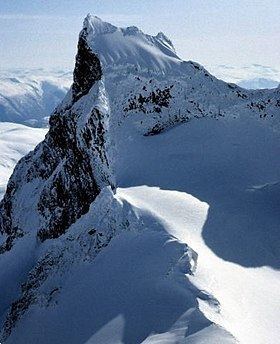
Store Austanbotntind (official form on maps Store Austanbotntinden) is a mountain on the border of the municipalities of Luster and Årdal in Sogn og Fjordane county, Norway. It is the highest peak in the western part of the Hurrungane mountain range. The mountain is located in Jotunheimen National Park, about 12.5 kilometres (7.8 mi) southeast of the village of Skjolden. The easiest route to the summit involves climbing, though relatively easy, and crossing of an exposed snow flank.
Contents
Map of Store Austanbotntind, 6884 %C3%98vre %C3%85rdal, Norway
The nearby mountains Store Skagastølstind, Vetle Skagastølstind, and Midtre Skagastølstind are all located about 5.5 kilometres (3.4 mi) to the northeast of Store Austanbotntind.
Name
The first element is the name of the valley Austanbotnen and the last element is the finite form of tind which means "mountain peak". The name of the valley is a compound of austan which means "eastern" and the finite form of botn which means "bottom" or "end of a valley".