
Topo map 1518 III Sygnefjell Prominence 450 m | Elevation 2,068 m Mountain range Hurrungane | |
 | ||
Similar Steindalsnosi, Store Skagastølstind, Galdhøpiggen, Jervvasstind, Storebjørn | ||
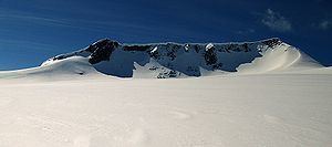
Fannaråki (or Fannaråken) is a mountain in the municipality of Luster in Sogn og Fjordane county, Norway. The 2,068-metre (6,785 ft) tall mountain is located in the Jotunheimen National Park, just south of the lake Prestesteinsvatnet and the Sognefjellsvegen road. This mountain is located about 6 kilometres (3.7 mi) north of the Skagastølstindane mountains (Store Skagastølstind, Vetle Skagastølstind, Midtre Skagastølstind, Sentraltind, Store Styggedalstind, and Jervvasstind).
Contents
Map of Fannar%C3%A5ki, 6877 Fortun, Norway
NameEdit
The first element is derived from the word fonn which means "glacier made of snow" and the last element is the finite form of råk which means "mountain ridge".
GuidebooksEdit
References
Fannaråki Wikipedia(Text) CC BY-SA