
Elevation 51 m (167 ft) Area 63.06 km² Population 2,453 (31 Dec 2008) Dialling code 05026 | Municipal assoc. Steimbke Time zone CET/CEST (UTC+1/+2) Local time Monday 8:44 AM Postal code 31634 | |
 | ||
Weather 3°C, Wind NE at 3 km/h, 83% Humidity | ||
Steimbke is a municipality in the district Nienburg, in Lower Saxony, Germany. It is situated approximately 12 km east of Nienburg, and 40 km northwest of Hanover, in a swamp and heathland, whereas the Blindesee takes centre stage.
Contents
Map of 31634 Steimbke, Germany
Municipality of Steimbke
The villages Steimbke, Wendenborstel, Glashof, Eckelshof, Lichtenhorst, Lichtenmoor, and Sonnenborstel comprise the municipality of Steimbke. Steimbke is also the seat of the ("collective municipality") Steimbke.
Municipal council
The municipal council Steimbke has 12 members elected and a mayor elected directly. Since the local election on September 10, 2006, two parties and one Wählergemeinschaft represent it.
History
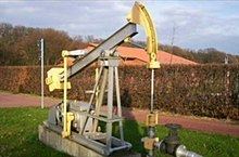
In development of the village, the industrial union "Gewerkschaft Brigitta" had the greatest share in 1934 by beginning oil production. "Brigitta" established an estate for industrial workers with bounteous sports facilities, a stadion with flood light and an indoor- as well as an outdoor swimming pool. In the meantime, the reduction of oil production has resulted to the abolishment of the pumpjacks that in former times have been Steimbke's landmark. By the date of June 30, 2005, Steimbke had a population of 2.739.