
Country United States County Pierce Area code 253 Elevation 23 m Population 6,122 (2013) | Time zone Pacific (PST) (UTC-8) FIPS code 53-67770 Zip code 98388 Local time Sunday 11:43 PM | |
 | ||
Weather 7°C, Wind S at 13 km/h, 97% Humidity | ||
Haunted lakewood steilacoom washington
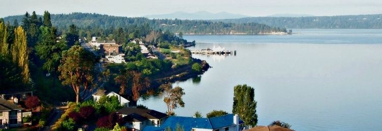
Steilacoom (/ˈstɛlkəm, -ləkəm/) is a town in Pierce County, Washington, United States. The population was 5,985 at the 2010 census. Steilacoom is on the coast of Puget Sound, on a branch not visible on the map to the right. Steilacoom incorporated in 1854 and became the first incorporated town in what is now Washington state. It has also become a bedroom community for soldiers stationed at Joint Base Lewis-McChord.
Contents
- Haunted lakewood steilacoom washington
- Map of Steilacoom WA USA
- History
- Geography
- Transportation
- Education
- 2010 census
- 2000 census
- Notable residents
- References
Map of Steilacoom, WA, USA
Based on per capita income, Steilacoom ranks 61st of 522 areas ranked in the state of Washington.
History
The origin of the name "Steilacoom" is unclear. According to the Legacy Washington program, the town’s name is derived from an Indian word meaning “little pink flower.” Another version is that it was named by fur traders with the Hudson's Bay Company (HBC) and is an adaptation of Tail-a-Koom, the name of an Indian chief. In 1824 HBC chief factor John Work called it "Chilacoom". Another early spelling was "Chelakom". The Town of Steilacoom says it was named after the Steilacoom tribe, especially their main village in the Tacoma area, located on Chambers Bay. This village was called Scht’ləqʷəm, later anglicized as Steilacoom. William Bright says the name comes from the Southern Coast Salish subgroup /č'tílqʷəbš/, anglicized as "Steilacoom".
European-American settlement at Steilacoom was founded by Lafayette Balch, a sea captain from Maine, and it was officially incorporated in 1854. It is the oldest incorporated town in Washington. It has four individual buildings and sites listed on the National Register of Historic Places, including the oldest Catholic Church in the state and the first Protestant Church north of the Columbia River, as well as the Steilacoom Historic District, with 68 contributing properties.
Steilacoom's main source of early prosperity was the processing and export of lumber to San Francisco. When the United States Congress established the Washington Territory on March 2, 1853, Governor Isaac Stevens chose Steilacoom as the seat of Pierce County.
Steilacoom had the first jail in Washington and the first sawmill. The City of Lakewood has developed next to it, and the city is home to one of the two major state-run mental health facilities, Western State Hospital, on the site of what was once Fort Steilacoom.
Geography
.
Steilacoom is located at 47°10′12″N 122°35′40″W (47.170019, -122.594349).
According to the United States Census Bureau, the town has a total area of 2.07 square miles (5.36 km2), of which, 2.04 square miles (5.28 km2) is land and 0.03 square miles (0.08 km2) is water.
Transportation
There are no state highways in Steilacoom. Drivers can access Interstate 5 or State Route 512 by driving through the adjacent city of Lakewood.
BNSF operates a railroad running along Steilacoom's shoreline. However, there is no station in the city and passenger trains do not stop there. Passenger service to the city ended in 1971. WSDOT is currently planning a project to route passenger service to an inland route through Lakewood. Once complete, Steilacoom's rail line will be for freight only.
Pierce County maintains a Steilacoom-Anderson Island Ferry which departs from Steilacoom and serves Anderson and Ketron islands.
Education
Public schools are operated by the Steilacoom Historical School District #1, which was first established in 1854.
2010 census
As of the census of 2010, there were 5,985 people, 2,559 households, and 1,715 families residing in the town. The population density was 2,933.8 inhabitants per square mile (1,132.7/km2). There were 2,793 housing units at an average density of 1,369.1 per square mile (528.6/km2). The racial makeup of the town was 77.1% White, 4.7% African American, 0.7% Native American, 7.3% Asian, 1.4% Pacific Islander, 1.5% from other races, and 7.3% from two or more races. Hispanic or Latino of any race were 6.7% of the population.
There were 2,559 households of which 26.9% had children under the age of 18 living with them, 50.3% were married couples living together, 12.2% had a female householder with no husband present, 4.5% had a male householder with no wife present, and 33.0% were non-families. 26.7% of all households were made up of individuals and 8.5% had someone living alone who was 65 years of age or older. The average household size was 2.34 and the average family size was 2.79.
The median age in the town was 42.4 years. 20.3% of residents were under the age of 18; 9.2% were between the ages of 18 and 24; 23.5% were from 25 to 44; 29.6% were from 45 to 64; and 17.4% were 65 years of age or older. The gender makeup of the town was 48.3% male and 51.7% female.
2000 census
As of the census of 2000, there were 6,049 people, 2,570 households, and 1,721 families residing in the town. The population density was 2,916.9 people per square mile (1,128.3/km²). There were 2,674 housing units at an average density of 1,289.4 per square mile (498.8/km²). The racial makeup of the town was 78.46% White, 6.70% African American, 0.84% Native American, 5.87% Asian, 0.61% Pacific Islander, 1.65% from other races, and 5.87% from two or more races. Hispanic or Latino of any race were 5.41% of the population.
There are 2,570 households out of which 27.8% have children under the age of 18 living with them, 53.8% are married couples living together, 9.8% have a female householder with no husband present, and 33.0% are non-families. 26.5% of all households are made up of individuals and 7.2% have someone living alone who is 65 years of age or older. The average household size is 2.35 and the average family size is 2.83.
In the town, the age distribution of the population shows 22.8% under the age of 18, 9.2% from 18 to 24, 28.6% from 25 to 44, 26.0% from 45 to 64, and 13.3% who were 65 years of age or older. The median age was 38 years. For every 100 females there were 96.5 males. For every 100 females age 18 and over, there were 93.4 males.
The median income for a household in the town was $46,113, and the median income for a family was $54,725. Males had a median income of $40,505 versus $34,136 for females. The per capita income for the town was $27,124. About 6.9% of families and 8.1% of the population were below the poverty line, including 15.0% of those under age 18 and 3.7% of those age 65 or over.