
- elevation 1,102 ft (336 m) Discharge 39.73 m³/s Length 27 km | - min 58 cu ft/s (1.6 m/s) Basin area 831.4 km² Basin area 831.4 km² | |
 | ||
- average 1,403 cu ft/s (39.7 m/s) - max 18,000 cu ft/s (509.7 m/s) | ||
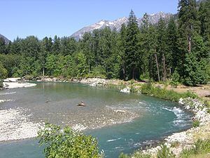
Washington s wild and scenic stehekin river
The Stehekin River is a river located in Washington state in the Pacific Northwest of the United States. It is the main river flowing into Lake Chelan. Miners arrived in Stehekin River Valley in the late 19th century. They were followed by homesteaders in the early 20th century. Today, the Stehekin River Valley is still a remote area that can only be reached by way of a 55-mile boat ride up Lake Chelan.
Contents
- Washington s wild and scenic stehekin river
- Map of Stehekin River Washington USA
- CourseEdit
- SettlementEdit
- RecreationEdit
- TributariesEdit
- References
Map of Stehekin River, Washington, USA
The river's name comes from the Columbia-Moses word stxwíkn', which means "the way through."
CourseEdit
The Stehekin River originates in the North Cascades near Cascade Pass in North Cascades National Park. It collects the waters of numerous headwater tributaries such as Pelton Creek, Doubtful Creek, and Basin Creek. Major peaks near the source of the Stehekin River include Boston Peak, Buckner Mountain, Booker Mountain, Sahale Mountain, Cascade Peak, Mix-up Peak, and Hurry-up Peak.
The Stehekin River flows generally west and southwest from these mountains, south of Park Creek Ridge to its confluence with Park Creek. Shortly below Park Creek the river receives Bridge Creek, one of its main tributaries. Bridge Creek joins from the north and drains northernmost Chelan County in North Cascades National Park. Bridge Creek and its tributaries drain a number of significant peaks including Goode Mountain, Storm King, Mount Logan, Black Peak, and others. Bridge Creek's source is located near Rainy Pass and Washington Pass along Washington State Route 20. The Stehekin River continues generally southeast to the northwest end of Lake Chelan. Shortly above the lake it receives Agnes Creek, another significant tributary, from the west. Agnes Creek drains the northernmost part of Wenatchee National Forest. Its final mile marks the boundary between North Cascades National Park and Lake Chelan National Recreation Area.
At the Agnes Creek confluence the Stehekin River exits the national park and enters the national recreation area. The Stehekin River enters Lake Chelan near Stehekin, a small community accessible only by boat. Roads from Stehekin follow the river up much of its valley. There are numerous campgrounds. The Pacific Crest Trail enters the Stehekin River basin from the south via Suiattle Pass, down South Fork Agnes Creek and Agnes Creek to the Stehekin River, then up the Stehekin to Bridge Creek and up Bridge Creek to Rainy Pass.
SettlementEdit
Because the region is so remote, the Stehekin River valley remained unsettled until the 1880s, when miners began infiltrating the region in search of mineral wealth. Between the years 1887–1910, a significant number of miners arrived looking for mineral deposits in the North Cascades. By 1890, there was a relatively large hotel Stehekin on Lake Chelan at the mouth of the Stehekin River. The hotel served tourists and fishermen as well as miners.
Over the centuries, the changing course of the Stehekin River deposited rich, alluvial sediments along the valley floor; however, it also left behind large boulders that made farming difficult. Nevertheless, early homesteaders began farming in the valley around 1910. The most desirable homesteads were located along the Stehekin River and its tributaries since these sites provided a reliable water supply for farming and natural transportation routes leading to Lake Chelan. The Buckner Homestead was one of the earliest farms along the Stehekin River. It is now listed on the National Register of Historic Places.
Because of the harsh winters, few early settlers remained in the valley year around. In the fall most homesteaders would leave the area, choosing to spend the winter in less isolated communities like Chelan. In the spring, families would return the Stehekin Valley to work their farms. Many of the early homesteaders supplemented their incomes by guiding miners into the backcountry and packing goods to remote mining claims. In 1902, the valley's first school was opened in a cabin located at the head of the Lake Chelan. It was later replaced by structure known as the Kronk cabin. Today, the cabin is the oldest school building in the Stehekin Valley. As new families arrived, the need for a real schoolhouse became clear. In 1921, valley residents select a site for a new school. The school was a log structure, built by local volunteers. The Stehekin School still exists, and is listed in the National Register of Historic Places.
As mining declined, subsistence farming, logging, and tourism sustained the residents of the Stehekin Valley. Apples were an important crop in the first half of the 20th century. In the winter, hunting and trapping a part of life for year around residents. Perhaps most important to the valley's economy was the arrival of the United States Forest Service. With the establishment of the Stehekin Ranger District in 1905, reliable seasonal work became available to valley residents.
Today, the Stehekin Valley is still quite isolated. There are fewer than one hundred year-around residents, most employed by the National Park Service. The only way into the valley is a 55-mile boat ride from Chelan. Two boats provided daily service between Chelan and Stehekin during the summer. In the winter, boat service is limited to two trips a week.
RecreationEdit
During the summer tourism is important since the area in now part of the Lake Chelan National Recreation Area. The Stehekin River is scenic and remote, offering whitewater rafting and kayaking opportunities. There are may camp sites available along the river. The Stehekin River is known as for its excellent fly-fishing. Rainbow and cutthroat trout fishing is best in the spring, and fishermen come for sockeye salmon in the fall.
TributariesEdit
These are the main tributaries of the Stehekin River: