
Elevation 2,286 m Mountain range Berchtesgaden Alps | Prominence 1,133 m | |
 | ||
Isolation 5.2 km → Wasserwandkopf First ascent touristically by Karl Thurwieser in 1825 Easiest route Western arête from the Mayrberg gap (I, marked) Parent ranges Reiter Alm, Berchtesgaden Alps Similar Wagendrischelhorn, Großes Häuselhorn, Mühlsturzhörner, Ganot, Hocheisspitze | ||
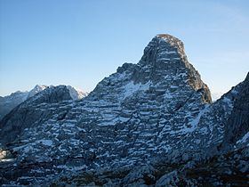
The Stadelhorn (2,286 m) is the highest and most prominent peak in the Reiter Alm on the Austro-German border, lying on the boundary between the states of Bavaria and Salzburg.
Map of Stadelhorn, 83486 Ramsau bei Berchtesgaden, Germany
The Stadelhorn is a popular, but rather exposed hiking summit. The view from the top extends from the Untersberg, the Hochkalter and Watzmann over the Leoganger Steinberge and Loferer Steinberge to the Sonntagshorn as well as large parts of the Lower Saalach valley. In addition, on clear days, the Stadelhorn offers a view from the Großer Priel in the east over the Dachstein and the High Tauern - including the Großglockner and Großvenediger - to Germany's highest peak, the Zugspitze, in the west. At the foot of the Stadelhorn on the Austrian side are the villages of St. Martin b. Lofer, Lofer and the parish of Unken; on the Bavarian side is the Klausbach valley and the Hintersee lake.
The normal route to the top of the Stadelhorn runs along the western arête (Westgrat) beginning at the Mayrberg gap (Mayrbergscharte, 2055 m). From here there are various options:
Direct climbs:
Ascents via the Roßkar gap (Roßkarscharte) and the upper Wagendrischel cirque (Wagendrischelkar):
Unlike its eastern neighbour, the Großes Mühlsturzhorn, the Stadelhorn has fewer climbing options, although an ascent does require a head for heights and sure-footedness. Only a sports climbing tour up the southwest face is used more often.