
 | ||
St. Paul Island is a small uninhabited island located approximately 24 km (15 mi) northeast of Cape North on Cape Breton Island and 71 km (44 mi) southwest of Cape Ray on Newfoundland; it is along the boundary between the Gulf of St. Lawrence and the Cabot Strait.
Contents
Map of St Paul Island, Victoria, Subd. A, NS, Canada
An extension of the Appalachian Mountains and the Cape Breton Highlands, the highest point on St. Paul Island is 147 m (485 feet) atop “Croggan Mountain.”
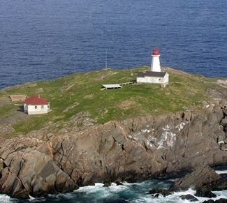
St. Paul Island is approximately three miles long by one mile wide at its widest point. It is formed of granite and is extremely rugged with its shores being completely encircled by rockface cliffs. It is split by a narrow channel that fills with sea water. No land mammals inhabit the island, although it is inhabited by numerous seabirds. Its ecosystem is considered fragile and due to the danger posed by visiting the island, visits must be cleared beforehand with the Canadian Coast Guard which administers the island on behalf of its owner, the Government of Canada.
The island is nicknamed the “Graveyard of the Gulf” (of St. Lawrence) as it is fog-bound throughout much of the navigation season and posed a significant hazard during the Age of Sail. Although it may have seen use by the Mi’kmaq Nation, it is believed to have been discovered by John Cabot.
A lighthouse was first established on the island in 1839. This lighthouse burned down in 1916. It was replaced by a cast iron cylindrical lighthouse in 1917. This was in turn replaced by an automated system in 1962.
With the light station now automated using solar power, the island sees few visitors, aside from Canadian Coast Guard helicopters on maintenance trips. The island used to host a Marconi wireless station and it still sees occasional amateur radio operators who use the callsign prefix CY9. Other visitors include birdwatchers and SCUBA divers.
ClimateEdit
St Paul Island experiences a marine influenced Subarctic Climate, with borderline Oceanic and Humid Continental Climate characteristics. On rare occasions, the temperature can rise rapidly and briefly when southwesterly winds blowing offshore from mainland Cape Breton reach the island. The highest temperature ever recorded on St Paul Island was 30.0 °C (86 °F) on 14 August 1944. The coldest temperature ever recorded was −23.3 °C (−10 °F) on 29 December 1933, 10 February 1934, and 6 February 1950.