
- elevation 600 ft (183 m) Length 120 km | - elevation 577 ft (176 m) | |
 | ||
- average 2,135 m/s (75,397 cu ft/s) Similar | ||
The St. Marys River (French: rivière Sainte-Marie), sometimes written as the St. Mary's River, drains Lake Superior, starting at the end of Whitefish Bay and flowing 74.5 miles (119.9 km) southeast into Lake Huron, with a fall of 23 feet (7.0 m). For its entire length it is an international border, separating Michigan in the United States from Ontario, Canada.
Contents
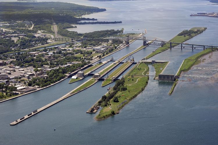
Map of St Marys River
The twin cities of Sault Ste. Marie, Ontario, and Sault Ste. Marie, Michigan are connected across the St. Marys River by the Sault Ste. Marie International Bridge. The St. Marys Rapids are just below the river's exit from Lake Superior and can be bypassed by huge freight ships through the man-made Soo Locks and the Sault Ste. Marie Canal.
Two of the Ontario tributaries of this river are the Garden River and the Bar River. Other Canadian tributaries include Fort Creek, the Root River, the Little Carp River, the Big Carp River, the Lower Echo River, Desbarats River, and the Two Tree River. The American tributaries to the St. Mary River are the Gogomain River, the Munuscong River, the Little Munuscong River, the Charlotte River, and the Waiska River.
History
Before Europeans arrived, Native Americans fished, traded, and maintained a portage around the rapids. French explorer Étienne Brûlé was the first European to travel up the rapids in about 1621. In 1641 Jesuit priests Isaac Jogues and Charles Raymbault ventured the same route as Brûlé, finding many Ojibwe at the rapids, and named it Sault Ste. Marie. Sault (Middle and early Modern French spelling of saut) means "jump"; hence, the secondary meaning "rapids" because the water 'jumps.'
Fort St. Joseph was built on the Canadian shore in 1796 to protect a trading post, and ensure continued British control of the area. The fort fulfilled its role in the War of 1812.
The first modern lock was completed in May 1855 by Erastus Corning's St. Mary's Falls Ship Canal Company, and was known as the "American Lock". Today, there are four parallel locks on the American side of the river, although only two are in regular use. The Soo Locks were made a part of the Great Lakes Waterway system in 1959.
Partially due to the American refusal of passage through the Soo Locks during the Wolseley Expedition, a Canadian Lock was built in 1895. The current Canadian Lock is used for recreational boats and is a National Historic Site of Canada.
Islands
Bridges
The Sault Ste. Marie International Bridge, a steel truss arch bridge, takes road traffic across the river. Directly to the west is the Sault Ste. Marie International Railroad Bridge, which carries rail traffic on a single set of tracks.
Power plants
The Edison Sault Electric Hydroelectric Plant, located at the eastern end of the Sault Ste. Marie Power Canal which runs between Lake Superior and Lake Huron through the city south of the American locks, is one of the longest hydroelectric plants in the world at 1,340 feet (410 m) in length. The plant consists of 74 three-phase generators capable of generating 25 to 30 megawatts. It was completed in 1902. The hydro plant is faced with stone quarried during the excavation of the Sault Ste. Marie Power Canal.
The United States Army Corps of Engineers owns and operates a hydroelectric generating plant directly north of the American locks.
Finally, the Francis H. Clergue Generating Station, owned and operated by Brookfield Renewable Energy, Inc., is a hydroelectric generating plant located directly north of the Canadian lock with a generating capacity of 52 MW. It was completed in 1981.
Canal
The Edison Sault Power Canal is used to power the Saint Marys Falls Hydropower Plant at its eastern end. The canal separated downtown Sault Ste. Marie, Michigan, from its mainland, making it an island. It was begun in September 1898 as the Michigan Lake Superior Power Company Canal, but completed by Edison Sault Electric Company in June 1902. Measured from its headgates to its end at the power plant, it is 2.25 miles (3.62 km) in length, between 200 feet (61 m) and 220 feet (67 m) wide, and 24 feet (7.3 m) deep. The water runs down the canal at speeds upwards of 7 miles per hour (11 km/h).
Locks
The American Soo Locks are the major transportation route around the St. Marys Rapids, but the Canadian Sault Ste. Marie Canal is still used by recreational and tour boats.
Other works
A set of compensating works are located at the mouth of the rapids, which are used to control the outflow of water from Lake Superior. The works consists of 16 gates, half of which are on the American side, and the other half on the Canadian side of the river. They were completed between 1901 and 1921. This flow is controlled by the International Joint Commission.
A concrete berm was constructed along the north side of the rapids as remedial works to protect fish spawning habitat from lower outflow through the rapids. This was due, in part, to an increase of water outflow from the three hydroelectric dams.
Pollution
The Saint Marys River is listed as a Great Lakes Areas of Concern in the Great Lakes Water Quality Agreement between the United States and Canada.