
- land 0.36 sq mi (1 km) - summer (DST) CDT (UTC-5) Area code 504 | - water 0.00 sq mi (0 km), 0% Area 93 ha | |
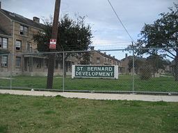 | ||
St. Bernard Projects was a neighborhood of the city of New Orleans and was one of the Housing Projects of New Orleans. A subdistrict of the Mid-City District Area, its boundaries as defined by the City Planning Commission were: Harrison Avenue to the north, Paris Avenue to the east, Lafreniere Street and Florida Avenue to the south and Bayou St. John to the west.
Contents
- Map of St Bernard Area New Orleans LA USA
- Geography
- Adjacent Neighborhoods
- Boundaries
- Demographics
- History
- References
Map of St. Bernard Area, New Orleans, LA, USA
Geography
Fairgrounds is located at 29°59′49″N 90°04′46″W and has an elevation of 0 feet (0.0 m). According to the United States Census Bureau, the district has a total area of 0.36 square miles (0.9 km2). 0.36 square miles (0.9 km2) of which is land and 0.00 square miles (0.0 km2) (0.0%) of which is water.
Adjacent Neighborhoods
Boundaries
The City Planning Commission defines the boundaries of St. Bernard Projects as these streets: Harrison Avenue, Paris Avenue, Lafreniere Street, Florida Avenue and Bayou St. John.
Demographics
As of the census of 2000, there were 6,427 people, 2,020 households, and 1,576 families residing in the neighborhood. The population density was 17,853 /mi² (7,141 /km²).
As of the census of 2010, there were 974 people, 403 households, and 231 families residing in the neighborhood.
History
Located in the city's 7th Ward, the complex was built over a few decades, beginning in the 1940s and has the distinction of being the 2nd largest housing project in the city. Like most public housing developments, it was not a very safe complex but by the standards set by other facilities in the city, like the Magnolia Projects, it was one of the city's safer projects until planned closures began and residents of the St. Thomas Projects and Desire Projects were moved into the St. Bernard.
It was closed after Hurricane Katrina, much to the dismay of residents and activists.
Survivors Village, a tent city created by residents of New Orleans housing projects, was established on June 3, 2006 to call attention to what participants and supporters say are violations of the UN International Policy on Internally Displaced Persons.
The project was torn down in mid-2008, and is currently being rebuilt as Columbia Parc, a mixed-income neighborhood.
Between 2002 and 2003 St. Bernard had total of 25 homicides, 13 slayings in 2002 and 12 in 2003.