Population 1,263 Post town PERTH Local time Friday 6:48 AM | OS grid reference NO196211 Sovereign state United Kingdom Postcode district PH2 Dialling code 01738 | |
 | ||
Weather 11°C, Wind S at 16 km/h, 95% Humidity Scottish parliaments North Tayside, North East Scotland | ||
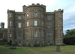
St Madoes (pronounced Saint May-Doe's) is a village in the Carse of Gowrie in Scotland, developed around Pitfour Castle. It is believed, however, that there has been settlements in the beginning of the century due to the discovery of several standing stones, as well as the St Madoes stone, a well-preserved Pictish cross.
Map of St Madoes, Perth, UK
Local amenities at St Madoes include a small shop, two parks, a primary school and an 18th-century church built upon earlier remains. It is believed the original drawings for the church were done by the architect Robert Adam (1728-1792) the design and layout is very similar to the only other known Robert Adam country kirk (Kirkoswald near Culzean Castle) with the most noted similarity being the gallery (or Laird’s Loft) on the back wall, facing the central pulpit. Adam also designed Pitfour Castle. Both buildings were funded by the laird John Richardson (1760-1821), a wealthy local man involved with the salmon fisheries of the Tay. Recently the village has started expanding due to the building of a large housing estate.
