
Sovereign state United Kingdom | Country Wales Postcode district CF | |
 | ||
St Georges super Ely, also known as St Georges, is a small village and community in the western outskirts of Cardiff, in the Vale of Glamorgan, South Wales. Lying to the northwest of Culverhouse Cross, between Peterston-super-Ely and Michaelston-super-Ely, it contains a medieval church and ruined manor house dated to the fifteenth century.
Contents
Map of St George's, Cardiff, UK
History
In the 1870s, John Montgomery Traherne of the wealthy Traherne family was the Reverend of St Georges.
Geography
St Georges super Ely lies to the northwest of Culverhouse Cross, beyond Coedarhydyglyn, and to the east of Peterston-super-Ely. It can also be accessed by road from Michaelston-super-Ely, across the A4232 road. The Cardiff-Bridgend railway and River Ely pass through the village.
Landmarks
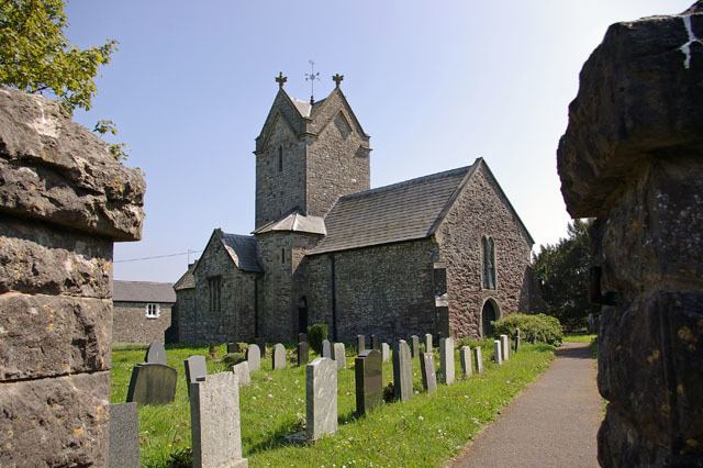
The village contains a church, dedicated to Saint George, which dates to the fourteenth century. It is Grade II* listed. Built in the form of a Greek or St. George's cross, it is described by Geoffrey R. Orrin as "one of the smallest cruciform churches in the diocese if not in Wales".
At nearby Castle Farm is the Grade I listed Castle Farmhouse, overlooking the River Ely. The medieval manor house, which was known as St George's Castle. was built by the Malefant family in the 15th century, replacing an earlier hall belonging to the Sullys. The upper chamber is now one room; it was once split into a hall and a solar. The nineteenth century mansion, Coedarhydyglyn, lies to the south of the village.