
OS grid reference SW 978 719 Sovereign state United Kingdom Dialling code 01208 | Unitary authority Local time Friday 1:12 AM | |
 | ||
Population 734 (United Kingdom Census 2011 including Edmonton and Engollan) Weather 12°C, Wind S at 32 km/h, 94% Humidity | ||
St Breock (Cornish: Nanssans) is a village and a civil parish in north Cornwall, England, United Kingdom. The spelling St Breoke was also formerly in use.
Contents
Map of St Breock, Wadebridge, UK
St Breock village is 1 mile (1.6 km) west of Wadebridge immediately to the south of the Royal Cornwall Showground. The village lies on the eastern slope of the wooded Nansent valley. The civil parish of St Breock is in Bodmin Registration District and the population in the 2001 census was 703, increasing to 725 at the 2011 census. The parish extends approx five miles (8 kilometres) south of Wadebridge. To the north, the parish is bounded by the River Camel, to the west by St Issey parish and to the east by Egloshayle parish. Together with Egloshayle it was one of the two parishes within which the town of Wadebridge developed.
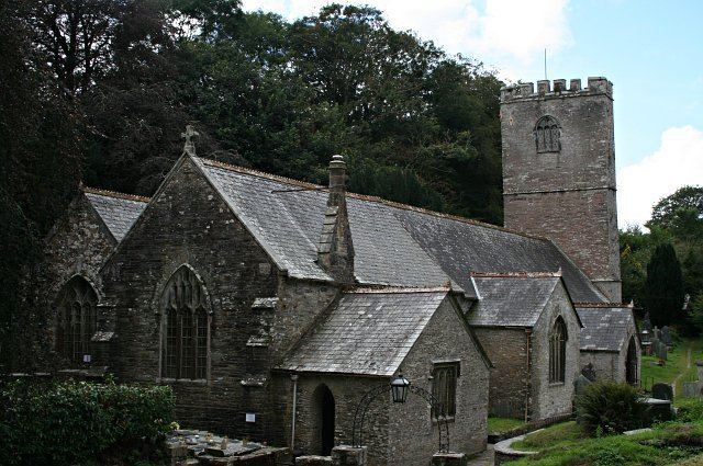
Parish Church
The parish church grid reference SW 977 717 is dedicated to St Briocus and dates back to the 13th century although it was extensively rebuilt in 1677. (The aisle, south transept and porches are additions of the 15th and 16th centuries.) The church has a battlemented tower with a ring of five bells. It is situated beside the stream in the valley bottom and in 1965 suffered damage in a major flood. The nave is longer than usual in a parish church: this may be connected to the fact that the Bishops of Exeter owned the manor of Pawton before the Reformation and had a palace there. In 1790 the rector here was John Molesworth and his wife Catherine Molesworth was an amateur artist.
The church contains some fine monuments to members of the Tredeneck family and one of 1598 to William and Jane Viell. The heirs of the Viell family in the 17th century were the Prideaux family of Prideaux Place, which still owned the manor of St Breock in 1968. There is a brass probably also to a Tredeneck, ca. 1520. The church organ was the work of 'Father' Willis. Seth Ward, afterwards a bishop, was briefly the incumbent here.
Manor of Pawton
The Manor of Pawton, already established in Saxon times, was very large, extending to six whole parishes and parts of four others. It was granted to the Bishops of Sherborne by King Egbert of Wessex and held by their successors until it was alienated under Henry VIII. In 1086 there were 44 hides of land, land for 60 ploughs, 40 villagers and 40 smallholders; pasture 12 sq leagues, woodland 2 sq leagues. Charles G. Henderson wrote in 1925 that slight remains of the bishop's palace and deer park were still to be seen. On the down above Pawton is a very large barrow with massive dolmen. At Nanscowe Farm a pillar stone of the 5th or 6th century with inscription meaning 'To the son of Ulcagnus; and to Severus' (in Latin).
Prehistory
Around two miles south of the village stands the St Breock Downs Monolith, a 16 ft (5 m) high prehistoric standing stone. It is the largest and heaviest prehistoric standing stone in Cornwall. Around one mile northwest of the monolith is a prehistoric dolmen known as Pawton Quoit.