
Area 130 ha | ||
 | ||
Islands Avocare Island, Ile du Sud, Pearl Islet, Palm Islet | ||
Map of St. Brandon
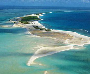
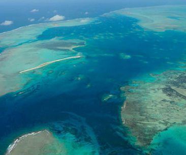
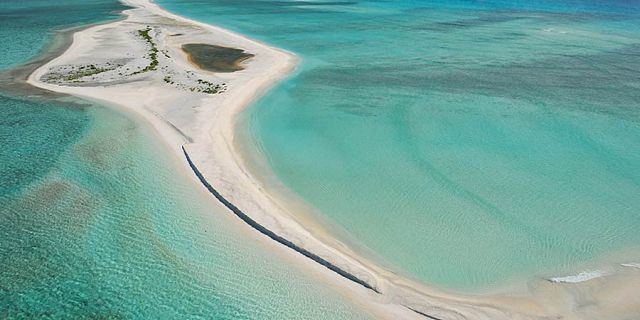
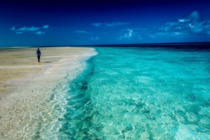
Saint Brandon, also known as the Cargados Carajos Shoals, is an Indian Ocean archipelago about 430 kilometres (270 mi) northeast of Mauritius consisting of a number of sand banks, shoals and islets. Saint Brandon consists of five island groups, with about 28–40 islands and islets in total, depending on seasonal storms and related sand movements. There are 22 named islands and shoals. The archipelago is low-lying and is prone to substantial submersion in severe weather. It has an aggregate land area estimated variously at 1.3 km2 (0.50 sq mi) and 500 acres (2.0 km2). Economic activity in the region is limited to fishing on the very extensive shallow bank covering approximately 900 sq mi (2,300 km2) around the islands. By the early 19th century, most of the islands were in use as fishing stations. Geographically, the archipelago is part of the Mascarene Islands and is situated on the Mascarene Plateau formed by the separation of the Mauritia microcontinent during the separation of India and Madagascar about 60 million years ago.
Contents

Politically, Saint Brandon is part of the territory of Mauritius and is grouped within the Outer Islands of Mauritius along with Agaléga, Tromelin (sovereignty disputed with France) and the Chagos Archipelago (sovereignty disputed with Britain), including Diego Garcia. The Outer Islands are defined as "all the islands comprised in the State of Mauritius other than the Islands of Mauritius and Rodrigues". They are administered from Port Louis by the Outer Island Development Corporation (OIDC), which is responsible for their management and development and reports to the prime minister's office. Under a judgment by the Judicial Committee of the Privy Council on 30 July 2008, 13 of the outer islands were deemed to have been a permanent grant to the Raphael Fishing Company Ltd.
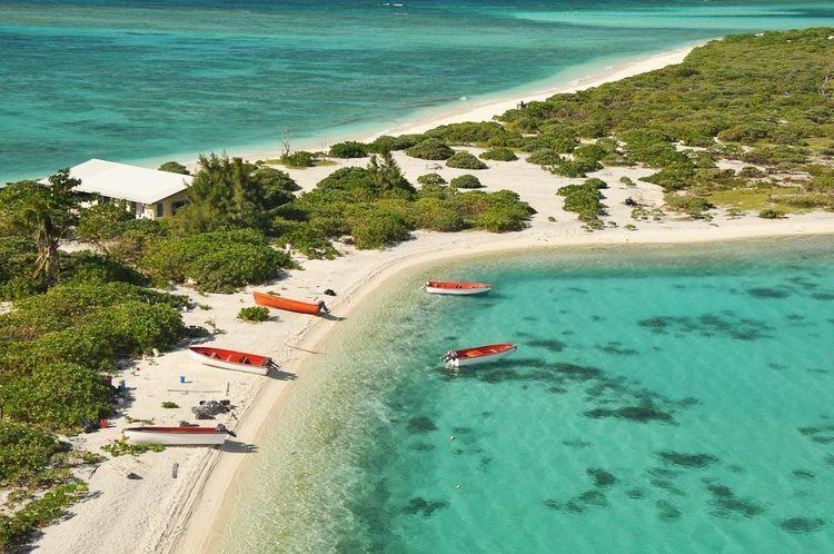
The reef measures more than 50 kilometres (31 mi) from north to south, and is 5 kilometres (3.1 mi) wide, cut by three passes. The reef area is 190 km2 (73 sq mi). The islands have a small transient population, mostly fishermen, counted at 63 people on census night in 2001. The bulk of this transitory population, approximately 40 people, live on Île Raphael, with smaller settlements existing on Avocaré, Coco, and Île du Sud. A settlement on Albatross Island was abandoned in 1988. The islands are rich in marine flora and fauna, but on some islands the latter have been severely affected by the uncontrolled presence of rats.
Geography
In the past, Cargados Carajos was a large, volcanic island (part of the Mascarenes, caused by the Réunion hotspot). Over time however, the island eroded until it became submerged and a coral atoll was left behind. The archipelago is part of the Mascarene plateau, a submarine plateau north and east of Madagascar that is the second largest in the Indian Ocean after the Kerguelen Plateau.
Individual islets on the reef include, roughly north to south, the following:
A number of unnamed islands and sand cays complete the Cargados. The total number of islands on the reef is close to 40.
Siren Island, Île du Sud, Pearl Island (Île Perle), and Frigate Island (Île Frégate) are west of the reef, while North Island (Île du Nord) is about 4 kilometres (2.5 mi) northeast of the northern tip of the reef.
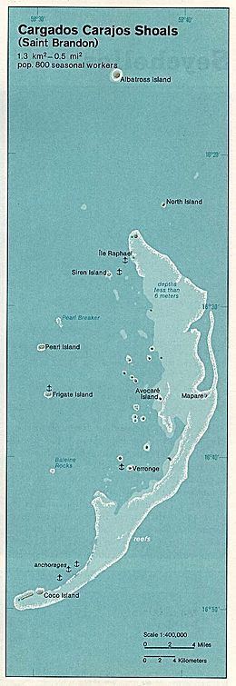
Albatross Island, about 18 kilometres (11 mi) north, is geographically a separate single coral island at location 16°15'S, 59°35'E.
Albatross Island is the highest (its highest point is 6 m (20 ft) above sea level) and the largest of the islands in the group, with an area of 1.01 km2 (0.39 sq mi), followed by Raphael, Tortue, Avocaré, Coco Island and Île du Sud.
The main settlement is on Île Raphael, which is held by the Raphael Fishing Company together with twelve other islands (l'île du Sud (or l'île Boisées), Petit Fou, l'Avocaire, l'île aux Fous (Fous, Ile Fou), l'île du Gouvernement, Petit Mapou, Grand Mapou, La Baleine, l'île aux Cocos, Verronge, l'île aux Bois and Baleines Rocks) under a permanent lease. Île Raphael can have up to 35 resident employees and a coast guard and meteorological station (with eight residents in 1996). Smaller settlements exist on Avocaré, Coco, and Sud; the settlement on Albatross was abandoned in 1988.
Ecology
Cargados comprises about 190 km2 (73 sq mi) of reefs. It has perhaps the largest algal ridge in the Indian Ocean. Coconut trees can be found on a few islands as well as bushes and grass. The islands are covered with white granular sand from eroded coral, and a thick layer of guano can be found in most places.
The shoreline is principally basalt boulders cemented basally by beachrock. The peripheral fringing reefs are exposed to a considerable south-east swell; accumulated water flows with dangerous velocity through the pass between Le Chaland and Ile des Deux Cocos (Procter and Salm, 1974). The reefs are described by Sabn (1976). The western part of the bay has a coral bank and a fringing reef, dominated by staghom Acropora, with an irregular front which merges with the coral banks; the reef flat has appreciable coral cover. North of this, or deeper into the bay, are several isolated patches of coral growing in deeper water. The eastern border has reefs with a greater diversity of corals, in particular, enormous hillocks of Pavona spp. with Mycedium tenuicostatum which is unusual in Mauritius. On the sandy substrate, Goniopora and Pontes provide hard substrate for several other species, notably Acropora and Pavona. Large tabular Acropora corals are also conspicuous, and when dead or overturned, provide substrate for other colonizers. These patches have expanded and fused to provide the numerous, large coral banks found in the Bay. Only twenty-eight coral species have been recorded which is probably due to the uniform habitat. Further off shore lies a peripheral fringing reef. This has not been surveyed, and approach to it is difficult because of the south-easterly swell. Noteworthy Fauna and Flora include ninety-one species of fish recorded (Procter and Salm, 1974). The Bras de Mer du Chaland has a fringe of mangroves especially along the southern border. This complex of low islands, coral reefs and sand banks arises from a vast shallow submarine platform. The main structure is a large, 100 km long crescent-shaped reef whose convex side faces towards the south-east trades and the South Equatorial Current. The reef front of the main reef recurves inwards at both ends and is cut by two or three passes. Behind the reef there is a vast area of shallows, sand banks and about twenty islets and cays. Some islets lie near the passes but the majority lie well to leeward of the main reef or on the southernmost recurved end. Many patch reefs lie amongst the several hundred square kilometres of shallow water and banks behind the main crescentic "backbone" (Faure, 1975). The most northerly island is Albatros, which lies about 12 miles (19.3 km) north of the main reef on the rich fishing grounds of Grandes Cameaux, which link up 150 miles (240 km) further north with the Nazareth Banks, another important fishing area. To the north of Cargados Carajos itself lies Ile du Nord (St Brandon). St Raphael, (Establishment Island) Iles at the northern end of the main reef, the main curve of which shelters Perle, Fregate, and Ile Paul in the central region, and a small chain of over a dozen islands at the southern end. Temperatures are 23-26°C, with rainfall of 1050 mm a year, most falling in January to April. The climate is dominated by the south-east trades. Cyclones can cause considerable damage. In 1948, Il aux Fous disappeared and Avoquer was submerged by 2 m of water. Petit ile Longue was swept away in a later cyclone, but is now reappearing. The South Equatorial Current is dominant. Coral Reefs of the World Volume 2 IUCN and UNEP (PDF). UNEP. 1988. p. 212. ISBN 2-88032-944-2.
The main reef has a very broad reef flat, extending up to several hundred metres across in parts. At its seaward edge, it is characterized by a massive algal ridge (Gardiner, 1907; Strauss in lilt., 9.7.84) whose dimensions would appear to make it by far the largest such structure that has been reported for the Indian Ocean. Together with much of the broad reef flat it is emergent at low tides. Apart from calcareous red algae it supports a few pocilloporoid corals. The reef slope to seawards is described by Strauss (in litt., 9.7.84) as largely devoid of live corals and with few fish. Down to at least 20 m depth the substrate is swept clear of attached biota, although on the sides of spurs or buttresses a few corals exist. Underwater photographs of some of the numerous knolls and banks behind the reef show that the density of corals and soft corals is typical of many very sedimented areas and shallow lagoons in the Indian Ocean. Sedimentation and turbidity is so high in the lee of the main reef, due to floating and suspended organic matter (Strauss in litt., 26.6.84), that visibility is reduced almost to zero in some places. The vast areas of sand which accumulate in the leeward platform suggest plentiful limestone production on and around the reefs and from the main seaward reef. Four scleractinian coral genera have been recorded from the shoals (Stoddart, 1984) but more will certainly be found. The islands are home to vast numbers of seabirds (Feare, 1984; Gardiner, 1907; Strauss in litt., 9.7.84). Staub and Gueho (1968) found a total of 26 species. Blue-faced Boobies Sula dactylatra melanops are found on Serpent Island and Ile du Nord. Large populations of Sooty Terns Sterna fuscata and White Terns Gygis alba occur on Albatros, St Raphael and Siren Islands. The islands were once important nesting sites for Green Chelonia mydas and Hawksbill Turtles Eretmochelys imbricata. The Coconut Crab Birgus latro may occur on the islets but there are no confirmed records. Cargados Carajos is reported to be the only place where the spider shell Lambis violacea has been found (Robertson, 1974). Scientific Importance and Research Scientific visits were made by Gardiner (1907) and Staub and Gueho (1968), who provided historical notes and whose interest was mainly ornithological and botanical. An expedition including U.S. National Museum scientists visited the shoals in 1976 (Strauss in litt., 26.6.84) and carried out mainly ichthyological studies, but provided the only data which is available on the reef biota. The algal ridge is an important feature of the shoals and appears to be the largest recorded for the Indian Ocean. Meteorological data has been recorded on St Raphael since 1944 and is of value in tracking Indian Ocean cyclones (Staub and Gueho, 1968). Management The Fishing Company is responsible for enforcement of both national and local regulations and to date management appears to have been quite good (UNEP, 1984). Coral Reefs of the World Volume 2 IUCN and UNEP (PDF). UNEP. 1988. p. 212. ISBN 2-88032-944-2.
In the 1960's, a turtle Reserve was established at Ile du Nord by the Raphael Fishing Company and landing on this island was permitted only in the summer (Staub and Gueho, 1968) under the Raphael Fishing Company's Regulations.
The reefs of Mauritius have been overfished and have suffered from the effects of tourism and other development. Mauritius plans to establish two marine reserves of coral reefs that were proposed for protection in 1974. This may demonstrate the pace of protection of natural resources in the area, slowed by the complications of new independence.
In 1975, the US Government proposed sending a scientific expedition to St Brandon together with the Smithsonian Institution and The National Geographic but this opportunity appears to have been lost at the time due to 'evasion... and buck passing'.
In 1984, the proposal was made to designate Perle and Fregate Islands as Nature Reserves (UNEP, 1984).
On some islands, rats, rabbits and chicken are damaging the native fauna which consist mainly of turtles and birds and it is unclear how much longer the archipelago will remain a refuge without international protection. The Mauritius economy is among the world's fastest growing. However, there is pressure to increase tourism. Sugar, introduced by the French, is Mauritius's main crop and represents 17 percent of the country's exports, but the price of sugar is dropping and increased tourism is seen as an important way to diversify the economy.
In 2010, a survey of seabirds and turtles of St Brandon was undertaken. "We estimated that 1 084 191 seabirds comprising seven breeding species and excluding non-breeders were present at the archipelago and we counted 279 turtle tracks and nesting pits of green turtles Chelonia mydas. Hawksbill turtles Eretmochelys imbricata were also present. Analyses of 30 different islets that make up the atoll showed that the seabird species mostly partitioned their use of islets based on islet size, with four species preferring larger islets and two species preferring smaller islets. Alien species introduced historically are still present and other threats, such as shipwrecks, remain. We propose conservation and other measures that should adequately protect the birds, turtles and coral reef by treating the atoll as a system."
St Brandon has been proposed for a Marine Protected Area by the World Bank, has been identified as an ‘Important Bird Area’ in Africa by BirdLife International, as a Marine Important Bird Area under the Nairobi Convention, and a Key Biodiversity Area by the CEPF.
In 2011, The Ministry of Environment & Sustainable Development issued the "Mauritius Environment Outlook Report" which stated that "There is an urgent need to allocate more resources for a closer monitoring of the environmental assets of the islands." It further recommended that St Brandon be declared a Marine Protected Area.
Raphael Fishing Company and the international conservationist Nathalie Boulle consult with and work closely with the Mauritian Wildlife Foundation in protecting and promoting the unique ecology of St. Brandon and, in 2013, the latter was awarded the President's Medal by HIH Princess Takamodo of Japan for being ‘a strong supporter of the Mauritius Wildlife Foundation, encouraging and supporting their application to become a Bird Life Partner, and sponsoring their delegate to the 2013 World Conference’; for 'core contributions and service to the Bird Life Partnership'; for 'being a major contributor to Bird Life's core work through unrestricted gifts as Founder Patron’
In the President's Report of the Mauritian Wildlife Foundation dated March 2016, St Brandon is declared an official MWF project in order to promote the conservation of the atoll.
In April 2016, The international conservationist Nathalie Boulle together with the Raphael Fishing Company Ltd., funded and organised a seven day fact-finding mission by some of the world's experts. Three highly acclaimed international experts (Professor Henk Bauwman (Ecotoxicology, Environmental Pollution, Bird Ecology); Professor Tony Martin (world’s foremost expert on marine mammals) and Dr. Nick Cole (herpetologist; MWF Islands Restoration Manager) inspected the islands to raise awareness about the need to protect the islands and to investigate, for the longer term, the effects of plastic and heavy metal pollution in the Indian Ocean.
In 2016, a documentary was made in French on Conservation on the Raphael Fishing Company islands held on permanent lease.
History
The atoll was probably discovered in 975 A.D. by Arabian sailors along with Dina Arobi ("Abandoned Isand" - Mauritius) and may be referred to as "Baixos" on the 1502 Cantino Planisphere. It was named in 1506 by Portuguese sailors who put ashore for provisioning on their way to India. Pirates have used the islands as a refuge. In 1598, the Dutch occupied the islands. Mauritius and its associated islands were colonised by the French in about 1715, granted by the King of France to the Compagnie des Judes in 1726 but retroceded to the French Crown in 1765. In the book 'The history of Mauritius, or the Isle of France, and the neighbouring islands; from their first discovery to the present time' by Charles Grant, the author quotes from his father's papers that "The bank of Corgados Garayos was, in 1742, the first object of the researches made by the boat named the Charles, and the tartan the Elizabeth, dispatched from the Isle of France (Mauritius) by order of M. Mahe de la Bourdonnais, at that time Governor of it. These two vessels having made it on the 27th of August, anchored there, and traced a plan of it, by which it is represented in the form of an horse-shoe, and of six leagues in extent, running north-north-east and south-west. These two boats not having been on the north side, and, consequently, not having perceived the isles which lay off it, its small extent, and the affinity of its latitude and longitude with that of Saint Brandon, on which an English vessel, called the Hawk, (le Faucon) was stranded on her return from Surat to Europe, induced me to consider it as one and the same shoal" Saint Brandon was referred to as 'Cargados' in Samuel Dunn's world map of 1794.
In 1806 Napoleon ordered the proclamation of the Civil Code as the Law of Mauritius and its islands. When, in 1810, Mauritius and its islands were taken by force of arms by Britain, the articles of capitulation confirmed to the inhabitants, in accordance with British constitutional practice, the continuance of their own laws, i.e. the Code Napoleon as it then stood.
The islands became part of a British Crown Colony in 1810. In 1820 the then Governor General of Mauritius granted jouissances in respect of the five groups as follows. He granted to Ozile Majestre alone a joussance exclusive over one group, the Iles Boisées, and to two individuals, Ozile Majestre and Dominique Bétuel, jouissances en partage over another group of six islands (Petits Foux, Lavocaire and four others). He granted three further jouissances exclusives to respectively M. Burceret (La Baleine and l’île aux Cocos), Mme. Veuve Raphaël (l’île Raphaël) and Mr William Stone (Ile Veronge and Ile aux Bois). All these jouissances were unlimited in time. Under a deed of transfer dated 4 September 1900, M. Louis Souchon, apparently the then owner of the jouissances relating to Iles Boisées and the six islands, sold the jouissances to the St Brandon Fish & Manure Co. Ltd. Under a second deed dated 20 September 1900 The Mauritius Cooperative Engrais Chimiques Co. Ltd., acting as owner of the remaining three jouissances, sold these to the St Brandon Fish & Manure Co. Ltd., which thus acquired all five groups of the St Brandon Archipelago. The Colonial Government was asked to give its consent to such sales, and on 19 October 1900 notified the purchaser company that it had no objection to the transfers provided that (in translation) “the jouissance which the said company possesses of the above islands and islets be converted in accordance with section 26 [of the 1874 Ordinance] into a permanent lease”. The Government’s requirement was accepted by the purchaser company and led to the Deed of 11 October 1901. The Deed, described as a “permanent lease by the Colonial Government to the St Brandon Fish & Manure Company Limited” was executed on behalf of the government by the Surveyor-General, M.de Coriolis, who on the government’s behalf ratified the two September 1900 sales to the purchaser company. The Deed formally declared that “… the jouissance currently held by the St Brandon Fish & Manure Company Ltd of the islands and islets referred to above be converted to a permanent lease in accordance with the above Ordinance, [with the company] claiming the rights of those to whom the Government of Mauritius granted it originally” and that the lease was to commence as from 2 October 1901. The “permanent lease” contained a number of conditions. In particular, the St Brandon Company was to export all the guano it found on the islands and to pay the Government a royalty of 5 rupees per ton. All the produce of the islands was to be sent to Mauritius. Furthermore “les clauses & conditions contenues aux actes de concession de la suds: jouissance sont maintenues dans leur intégralité & lieront la Société … envers le Gouvernement Colonial….” The company was also to pay the Government an annual sum of one rupee, which was due on 2 October each year.
In more modern times the islands were mined for phosphates derived from guano. Mining ceased in the mid-20th century.
The St. Brandon archipelago was surveyed by British colonial authorities on 31 March 1911 as part of the Census of Mauritius. This found a total population of 110, made up of 97 men (86 non-Indian and 11 Indian) and 13 women (10 non-Indian and 3 Indian). While the archipelago likely had a resident population at this point, as indicated by the 8 children under the age of 15 and the 5 people over the age of 60, there was also likely a seasonal component, with the largest population segment being men between 20 and 35. 73 men worked in fishing, 11 at the guano mines and 4 were ship's carpenters. Only one (male) person was recorded as having been born on St. Brandon.
The 1911 census reported that three of St. Brandon's 39 houses were built of stone and eight of wood, with 28 built of thatch. Most of these were single-room dwellings, but 10 had two rooms and one had three. There were also eight shops or stores and a one-room chapel.
In October and November 1917, Saint Brandon Isles and more specifically, the Cocos island, were used by the famous German Cruiser, "The Wolf" as a base to tranship coal and stores from the captured Japanese ship, the Hitachi Maru. The operation took three weeks. The stoking coal was necessary for the Wolf return to Germany. To do so, it had to run the gauntlet of British warships round the Cape through to the Atlantic. On 7 November 1917, The Wolf left the Coco Island lagoon and the accompanying Hitachi Maru was scuttled, some sixteen miles offshore.
In the 1921 census, the population had plummeted to just 22. There were 21 were men (ages 19–48) and just one woman, a married Catholic, aged 31. 14 people were identified as part of the "general population", with 11 of them born on Mauritius, one on Rodrigues and two in the Seychelles. In addition, there were 3 Indo-Mauritanians and 5 "other Indians" from Madras, Calcutta and Colombo.
The most common employment on St. Brandon in 1922 was agriculture, with a manager, assistant manager and 11 labourers. Only two young men were recorded as working as fishermen. Three men worked as carpenters, one as a mason, one as a shoemaker and another as a domestic servant. There was no indication that the guano mines were operating.
In 1925 the liquidators of the St Brandon Company sold the right to the permanent lease to France Ulcoq who sold it in 1928 to the Raphael Fishing Co Ltd (“Raphael Fishing”).
Mauritius, and its islands, became an independent state within the Commonwealth in 1968 and a republic in 1992. .
In 2011, The Ministry of Environment & Sustainable Development issued the "Mauritius Environment Outlook Report" which stated that "For the Outer Islands of ... St. Brandon, major improvements are required to promote development, environmental protection and judicious use of natural resources."
Shipwrecks
Shipwrecks on the low-lying, rocky reefs of St. Brandon have been recorded since as early as 1662.
On 12 February 1662, the Dutch East Indiaman sailing ship Arnhem wrecked itself on the rocks at St. Brandon.
In 1780s (?) - The English ship, The Hawk, foundered on Saint Brandon on her return to Europe from Surat.
In July 1818, the sailing vessel Cabalva, owned by the East India Company, struck the reef at St. Brandon and was destroyed.
On 15 September 1845, the sailing ship Letitia ran aground on Frigate islet.
On 3 October l969, the Russian tugboat Argus itself on the reef at St. Brandon. 38 men were rescued by local fishermen.
On 29 November 2014, during the second leg of the 2014–15 Volvo Ocean Race, the sailboat Team Vestas Wind ran aground on St. Brandon. The crew was safely rescued, and a complicated salvage operation succeeded in removing the wreck from the reef.
On 1 February 2015, the fishing vessel Kha Yang, with 250,000 litres of fuel in its tanks, ran aground on the reef of St. Brandon. 20 crew were rescued shortly after its grounding, and a salvage operation pumped the fuel from its tanks a few weeks later.
On 2 February 2017, the 190 meter long bulk carrier Alam Manis ran aground on Cargados Carajos . The bulk carrier was headed to Pipava from Richards Bay when it ran aground.