
 | ||
St Aidan's is a 400 hectare Country Park between Leeds and Castleford in West Yorkshire, England. The land was formerly an opencast coal mining area that was flooded after the riverbank collapsed. Repairs and remediation required its own act in Parliament to allow the necessary works to go ahead. Mining ceased at St Aidan's in 2002.
Contents
The Country Park opened on to the public in May 2013 under the care of the Royal Society for the Protection of Birds (RSPB). However, the car park and visitor centre were subsequently closed in July 2013 due to unresolved land issues. The Country Park remains open for those on foot, but the RSPB have dramatically scaled back their presence.
History
St Aidan's Country Park comprises the former St Aidan's opencast site, Lowther North opencast site and parts of the former Savile Colliery, Methley. In March 1988, there was a slope failure on the banks of the River Aire, resulting in a massive flood of 17,000,000 l (3,700,000 imp gal; 4,500,000 US gal) of water. Mining operations were suspended and remedial works costing £20 million were required to drain the site and re-route the river. The resultant deluge created a lake that was 100 ha (250 acres) in size and 70 m (230 ft) deep.
RAF Chinook helicopters were used to ferry sandbags into the breach, but it did not stop the water cascading in. Not only did the downstream river flow into the site, but the River Calder actually flowed upstream in the River Aire waterbed from Castleford until the water found a natural level.
Government documentation states that it was the Aire and Calder Navigation, whilst others list the Aire as being the source of the water that flooded St Aidan's. The failure came about just south east of Lemonroyd Lock where the two waterways converge. Mining was subsequently completed and then the site was converted into a wetland.
The Pontefract and District Archaeological Society won the Pitt Rivers award for their work on the preservation of the ships and heritage that was found in the abandoned river bed after the water was diverted. The find provided a unique insight into river trade in the seventeenth century onwards, including the hulls of four boats (virtually intact), various pottery and evidence of a medieval weir.
Ownership of the land was transferred in 2010 from UK Coal/Harworth Estates to St Aidan's Trust, a charity administered by Leeds City Council. The trust would then lease the land to the RSPB for 99 years on a peppercorn rent. The Country Park officially opened to the public on 25 May 2013. Unfortunately, due to unresolved land ownership issues, the RSPB withdrew its staffing and support in July 2013.
Location
St Aidan's is adjacent to the River Aire and the Aire and Calder Navigation. The reserve can be accessed via a network of paths, some of which run alongside the River Aire. It is approximately 2 miles from Woodlesford railway station.
Nearby are the residential areas of Allerton Bywater, Mickletown, Methley, Woodlesford, Swillington and Great Preston, all of which lie within an area bounded by three motorways: A1(M), M62 and M1.
Wildlife
St Aidan's is home to many species of bird including the bittern, great crested grebe, little owl, marsh harrier, and Eurasian skylark.
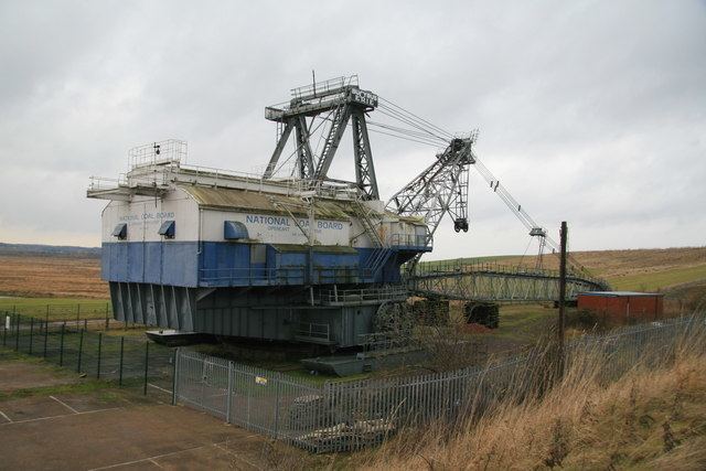
Dragline
There is a dragline known as "Oddball" at St Aidan's. Oddball, whose name refers to it having been built in the US to run on a 60Hz electrical supply rather than the UK standard 50Hz, was brought to the UK from the US in 1946 and weighs 1220 tons. The group Friends of St. Aidan's BE1150 Dragline claim that it is the largest preserved walking dragline excavator in Western Europe. The excavator was originally christened Clinchfield and was used to surface mine coal from the area now occupied by St Aidan's Country Park.
The group hold 'open days' throughout the year where visitors can look around the machine and sit in the cab.