
 | ||
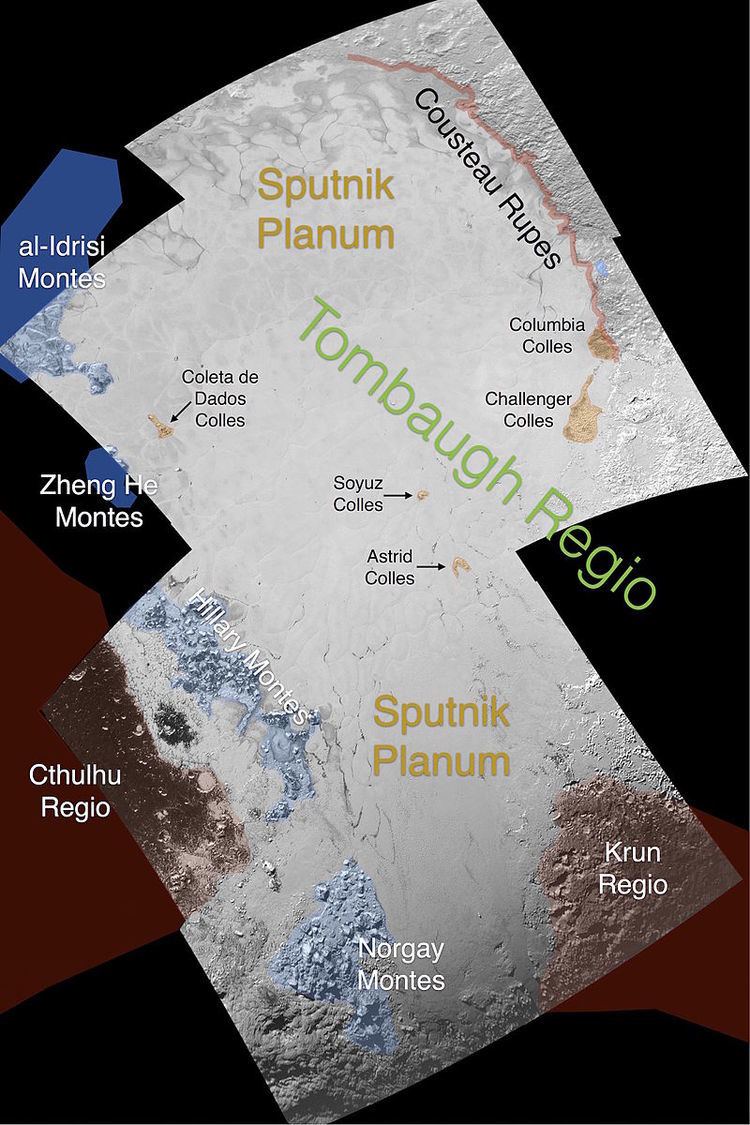
Sputnik Planitia /ˈspʌtnɪk pləˈnɪʃiə/, (English translation: Sputnik Basin), originally Sputnik Planum, is a high-albedo ice-covered basin on Pluto, about 1,050 by 800 km (650 by 500 mi) in size (similar to Hudson Bay). It lies mostly in the northern hemisphere, but extends across the equator. Much of it has a surface of irregular polygons separated by troughs. The polygons are on average about 33 km (21 mi) across. In some cases troughs are populated by blocky mountains or hills, or contain darker material. Sputnik Planitia constitutes the western lobe of the heart-shaped Tombaugh Regio. There appear to be wind streaks on the surface with evidence of sublimation. The dark streaks are a few kilometers long and all aligned in the same direction. The basin also contains pits that have possibly formed by sublimation. Sputnik Planitia is named after Earth's first artificial satellite. The planitia has no craters that were detectable by New Horizons, leading to the conclusion that its surface must be less than 10 million years old.
Contents
Composition
The ice composing the basin is thought to consist primarily of nitrogen ice, with smaller fractions of carbon monoxide and methane ice, although relative proportions are uncertain. At Pluto's ambient temperature of 38 K (−235.2 °C; −391.3 °F), nitrogen and carbon monoxide ices are denser and much less rigid than water ice, making glacial-like flows possible; nitrogen ice is the most volatile.
Origin
Sputnik Planitia may have originated as an impact basin that subsequently collected volatile ices. Alternatively, it has been suggested that the accumulation of ices in this location depressed the surface there, leading to formation of a basin via a positive feedback process without an impact.
The accumulation of several kilometers of nitrogen ice in the basin was in part a consequence of its higher surface pressure, which leads to a higher N2 condensation temperature. The positive temperature gradient of Pluto's atmosphere contributes to making a topographic depression a cold trap.
A high seasonal thermal inertia of Pluto's surface is an important driver of deposition of nitrogen ice at low latitudes. These latitudes receive less annual insolation than Pluto's polar regions due to its high obliquity (122.5°). The coldest regions on Pluto, on average, are at 30° N. and S. latitude; early in Pluto's history, ice would tend to accumulate at these latitudes in a runaway process due to the positive feedback association of increased albedo, cooling and further ice deposition (similar to the ice segregation that occurred on Iapetus). Simulations suggest that over a period of about a million years, the runaway process would collect much of the ice into a single cap even in the absence of a preexisting basin.
The accumulation of dense nitrogen ice would have contributed to making Sputnik Planitia a positive gravity anomaly, but by itself would not have been sufficient to overcome the topographic depression associated with the basin. However, other effects of an impact event (see below) could have also contributed to such an anomaly. A positive gravity anomaly could have caused polar wander, reorienting the spin axis of Pluto to put the planitia near the Pluto-Charon tidal axis (the minimum-energy configuration). Sputnik Planitia is presently close to the anti-Charon point on Pluto, a result that has less than a 5% probability of arising by chance. If Sputnik Planitia was created by an impact, then explaining the positive gravity anomaly requires the presence of a subsurface liquid water ocean; isostatic uplift of the ocean under the basin would account for most of the anomaly. Gradual freezing of such an ocean, in combination with polar wander and the loading of Sputnik Planitia with ice, would also explain the extensional tectonic features seen across Pluto. Alternatively, if the accumulation of ice in a single cap (without an impact) created a positive gravity anomaly that reoriented Pluto prior to formation of a basin, the tidal bulge raised by Charon would tend to maintain Pluto's orientation even if the positive anomaly later disappeared.
Convection cells
The polygonal structure is a sign of convection of the nitrogen/carbon monoxide ice, with ice warmed by heat from the interior welling up in the center of cells, spreading and then sinking at the ridged margins. Convection cells have about 100 m of vertical relief, with the highest points being at their centers. Modeling of nitrogen ice convection cells suggests a depth of about one tenth their width, or 3–4 km for most of the planitia, and a maximum flow rate of about 7 cm per year. Cell margins can become pinched off and abandoned as cells evolve.
Other obvious indications of ice flow visible in images of the planitia include examples of valley-type glaciers flowing down into the basin from adjacent eastern highlands (the right lobe of Tombaugh Regio), presumably in response to deposition of nitrogen ice there, as well as ice from the planitia flowing into and filling adjacent depressions. The planitia has numerous blocky hills (one to several km across) that form aggregations at cell margins up to 20 km across; these may represent floating chunks of detached water ice crust that were carried onto the planitia by glacial flow and were then collected into troughs by the convection. In some cases the hills seem to form chains along the entry paths of glaciers. The hills may also congregate in nonconvecting regions when they get stuck at locations where the nitrogen ice becomes too shallow.
The planitia has numerous pits that are thought to result from fracturing and sublimation of nitrogen ice; these pits also collect in the margins of convection cells. Often the bottoms of the pits are dark, which may represent an accumulation of tholins left behind by the subliming ice, or a dark substrate below the planitia, if the pits penetrate all the way through the ice. In regions of the planitia where convection cells are not apparent, the pits are more numerous.
Bordering montes
On its northwest, Sputnik Planitia is bordered by a chaotic set of blocky mountains, the al-Idrisi Montes, which may have formed via the collapse of adjacent water ice highlands onto the planitia.
On its southwest, the planitia is bordered by the Hillary Montes, rising 1.6 km (0.99 mi; 5,200 ft) above the surface, and, further south, the Norgay Montes, rising 3.4 km (2.1 mi; 11,000 ft) above the surface. These mountains also have a chaotic, blocky character. The mountains were named after Sir Edmund Hillary, New Zealand mountaineer, and Nepalese Sherpa mountaineer Tenzing Norgay, who were the first climbers to reach the summit of the highest peak on Earth, Mount Everest, on 29 May 1953. Some groups of hills in the basin are named after spacecraft; for example, “Coleta de Dados”, in honor of the first Brazilian satellite launched into space.
Immediately to the southwest of the Norgay Montes (context) is a large, circular mountain with a central depression, Wright Mons. It has been identified as a possible cryovolcano.