
Country United States County Pendleton Elevation 1,482 m Peak Spruce Knob | Topo map USGS Prominence 57 m | |
 | ||
Length 16 mi (26 km) approximately Similar Spruce Knob, Barton Knob, Gaudineer Knob, Bickle Knob, Mount Porte Crayon | ||
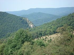
Spruce Mountain, in eastern West Virginia, USA, is the highest ridge of the Allegheny Mountains. The "whale-backed" ridge extends for only about 16 miles (26 km), from northeast to southwest, but several of its peaks exceed 4,500 feet (1,400 m) in elevation. The summit, Spruce Knob (4863 ft; 1482 m), is celebrated as the highest point in the state as well as the range, which covers parts of four states.
Contents
Map of Spruce Mountain, Western, WV 26814, USA
GeographyEdit
Spruce Mountain lies mostly within the Spruce Knob-Seneca Rocks National Recreation Area, a U.S. National Recreation Area (NRA) located within the Monongahela National Forest (MNF) in Pendleton County. It extends from the vicinity of Onego in the north to near Cherry Grove in the south. Brushy Run separates Timber Ridge — a spur of the main mountain — to the east. The ridgelines of Spruce Mountain and Timber Ridge continue to the north of US Route 33 as Hoffman Ridge and Smith Mountain, respectively. To the south (south of West Virginia 28) the line continues as Big Mountain.
Prominent peaks of Spruce Mountain, north to south, are: Horse Rock (4536 ft; 1383 m), Spruce Mountain Peak (4586 ft; 1398 m), Picea Benchmark (4613 ft; 1406 m), and Spruce Knob itself. Spruce Knob is the highest point in the eastern United States between the Adirondacks of New York and Mount Rogers (part of the Blue Ridge Mountains) in southern Virginia.
FloraEdit
As with almost the entirety of the MNF, most of the original Spruce Mountain upland forest was completely denuded by logging around the turn of the 20th century and now consists of second- or third-growth forest. (The only documented exception to this on the Mountain is the 17-acre (69,000 m2) North Spruce Mountain Old Growth Site. ) The present second-growth forest of Spruce Mountain is characterized by a dominance of sugar maple (Acer saccharum), American beech (Fagus grandifolia), and yellow birch (Betula lutea). Other characteristic species of the mixed mesophytic forest region are also present: tuliptree (Liriodendron tulipifera), basswood (Tilia heterophylla, T.floridana, T. neglecta), chestnut (Castanea dentata), yellow buckeye (Aesculus flava), red oak (Quercus borealis), white oak (Q. alba), and eastern hemlock (Tsuga canadensis). The upper reaches of Spruce Mountain also include areas termed northern hardwood and northern evergreen forest types. The former is typified by red oak, white ash (Fraxinus americana), basswood (Tilia spp.), red maple (Acer rubrum), and cherry (Prunus spp.). The latter is dominated by the Mountain's eponymous red spruce (Picea rubens). While not extending above the timberline, the stunted tree growth high on this windy mountaintop is relatively open.
FaunaEdit
The important presence of ruffed grouse (Bonasa umbellus) on the Mountain has been acknowledged by the establishment of the 1,750-acre (7.1 km2) Spruce Mountain Grouse Management Area by the MNF
RecreationEdit
Hiking trails — Huckleberry Trail, Lumberjack Trail, Spruce Mountain Trail — extend the length of the ridge. There are over 75 miles (121 km) of trails around the Mountain and a small 25 acre (10 ha) lake well stocked with trout on the west side. There are also two campgrounds on the Mountain; the larger (43 sites) is nearest the lake.