
- summer (DST) CEST (UTC+2) Area 17.53 km² | Elevation 505 m Local time Thursday 1:44 AM | |
 | ||
Weather 9°C, Wind NW at 19 km/h, 78% Humidity | ||
Stuzkova slavnos gymn zium spi sk star ves
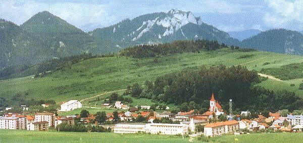
Spišská Stará Ves (German: Alt(en)dorf; Hungarian: Szepesófalu; Polish: (Stara) Spiska Wieś; Latin: Antiqua Villa) is a small town and urban municipality in Kežmarok District in the Prešov Region of north Slovakia.
Contents
- Stuzkova slavnos gymn zium spi sk star ves
- Map of 061 01 SpiC5A1skC3A1 StarC3A1 Ves Slovakia
- Ixfinity club spi sk star ves 1 birthday party
- History
- Geography
- Demographics
- References
Map of 061 01 Spi%C5%A1sk%C3%A1 Star%C3%A1 Ves, Slovakia
Ixfinity club spi sk star ves 1 birthday party
History
In historical records the town was first mentioned in 1272.
Geography
The town and municipality lies at an altitude of 505 metres and covers an area of 17.533 km2 (7 sq mi). It has a population of about 2335 people (2005). Spišská Stará Ves is the centre of Zamagurie region and is close to the Dunajec River.
Demographics
According to the 2001 census, the town had 2,355 inhabitants. 93.76% of inhabitants were Slovaks, 4.50% Roma, 0.53% Polish, 0.30% Czechs and 0.25% Ukrainians. The religious makeup was 93.25% Roman Catholics, 2.93% Greek Catholics, 1.66% people with no religious affiliation and 0.85% Lutherans.