
Population 11,703 (Ward2011) Sovereign state United Kingdom Local time Tuesday 6:51 PM | OS grid reference SE058233 Dialling code 01422 | |
 | ||
Weather 12°C, Wind S at 10 km/h, 77% Humidity | ||
Sowerby bridge flood works december 2015 calderdale council
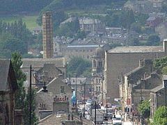
Sowerby Bridge /ˌsɔːrbi ˈbrɪdʒ/ is a market town in the Upper Calder Valley in Calderdale in West Yorkshire, England. The Calderdale Council ward population at the 2011 census was 11,703.
Contents
- Sowerby bridge flood works december 2015 calderdale council
- Map of Sowerby Bridge UK
- History
- Christ Church
- Government
- Geography
- Education
- Transport
- In popular culture
- Notable residents
- Traditions
- Boxing Day floods 2015
- References
Map of Sowerby Bridge, UK
History
Always pronounced Sorby Bridge, the town was originally a fording point over the once much-wider River Calder where it joins the River Ryburn. The town takes its name from the historic bridge which spans the river in the town centre. Before the Industrial Revolution the area was divided between the parishes of Sowerby, Norland, Skircoat and Warley. The boundaries between them being the rivers Calder and Ryburn and Warley Clough, which is now largely culverted. Textiles and engineering industry grew up around the bridge. By the mid-19th century the population had grown and the settlement became an urban district in the West Riding of Yorkshire in 1894.
From 1892 to 1930 Pollit & Wigzell manufactured stationary steam engines for the cotton and woollen mills of Yorkshire, Lancashire and India. Wood Brothers, an engineering and millwright company, also produced engines from its Valley Iron Works. The Markfield Beam Engine is an example for its work.
Council buildings on Hollins Mill Lane, the old swimming pool, council offices and fire station will be transferred to the community group, Sowerby Bridge Fire and Water, and will be renovated for community use.
Christ Church
The Anglican parish church, Christ Church, situated on Wharf Street, is a Grade II listed building. It was built in 1819 by John Oates The chancel was rebuilt in 1873-74 and the church was re-roofed 1894. The church is still active and the vicar is Revd. Canon Angela Dick
The first organ, built by John Ward of York, was installed in 1825, four years after the church opened. It was situated in the gallery above what is now the parish room. Ward also built the organ in the Halifax Square Chapel in 1821. This organ was dismantled in 1865 by Conacher of Huddersfield. Conacher installed a replacement at a cost of £266 (equivalent to £22,900 in 2015). In 1873-74 the church was extended and the organ was moved to its present location. In 1894, however, a major fire started from a candle in the organ and destroyed most of the chancel and nave roof, as well as the organ itself.
As part of the church reconstruction a new and considerably larger organ was provided by Abbott & Smith of Leeds. The organ saw no repairs until 1979, by when the church was unable to afford any restoration. Between 1979 and 1983 a further replacement organ, of some quality, was moved from the closed Bolton Brow Methodist Church. This had been originally built by James Jepson Binns of Bramley, Leeds. Its bellows had originally been pumped by a water engine connected to the Rochdale Canal below. The present organ retains the fine oak case and four stops of pipes from the Abbott and Smith organ and incorporates three stops from the organ at Warley Congregational Church. The instrument was converted to electric control between the keyboards and pipes. Some restoration work was completed in 2006 and a recent bequest, from the late Fred Seed, has been used to cover the cost of further work.
Government
The town is part of the Sowerby Bridge ward of the Metropolitan borough of Calderdale, part of the Metropolitan county of West Yorkshire.
Geography
Sowerby Bridge is situated about 3 miles (4.8 km) from Halifax town centre. It is at the confluence of the River Calder and River Ryburn, and the name Sowerby Bridge references its situation as a crossing point over the River Calder to the older settlement at Sowerby.
Education
There are two high schools in Sowerby Bridge.
Transport
The town is served by Sowerby Bridge railway station, which sees a regular service to Manchester, Bradford and Leeds on the Caldervale Line. Unfortunately this station has no public toilets although there are many interesting information panels about the local area.
The town is at the junction of the Calder and Hebble Navigation and the Rochdale Canal; Tuel Lane Lock on the Rochdale Canal is the deepest lock in the United Kingdom. The canal basin and warehouses where the canals meet, Sowerby Bridge Wharf, are listed buildings and house the Moorings Bar and Restaurant, 12-04 Restaurant and Temujin Mongolian Restaurant. The basin is the headquarters of the 12th Halifax Sea Scouts (M.o.D. No. 54 Royal Navy recognised) where Prince Charles opened the William Andrew Memorial Headquarters. Shire Cruisers run holiday hire canal barges, build narrow boats and provide mooring facilities.
In popular culture
Sowerby Bridge features in George Gissing's 1891 novel The Emancipated as the hometown of the protagonist Ross Mallard.
The canal basin was used as a filming location for the ITV comedy-drama Stay Lucky, and the ITV drama Dead Clever was set in the town. The 2014 BBC One drama Happy Valley was set in Sowerby Bridge and parts of the series were filmed in and around the town. Catherine's workplace is a former police station. Series writer and director Sally Wainwright grew up in Sowerby Bridge.
Notable residents
Traditions
Rushbearing, the annual ceremony of (now nominally) taking rushes to churches for covering the floors throughout winter, still takes place here over the first weekend of September.
Boxing Day floods 2015
Local river monitoring stations recorded a level of 3.55m between 12 pm and 6 pm, surpassing previous recorded highs of 2.43m (23 June 2012). Known flood plains, such as Dixie Woods and Sowerby Bridge Cricket Club, were submerged to an estimated depth of 2 feet (61 cm). The floods were reported as the worst in the area since 1968.