
Length 11 km Country United Kingdom | Basin area 13 km² | |
 | ||
Main source Confluence of unnamed stream and Black Castle Clough nr Rishworth361 metres (1,184 ft) Basin size 13 square kilometres (5.0 sq mi) Mouth | ||
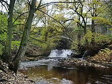
The River Ryburn is a river in West Yorkshire, England. It flows through the villages of Rishworth, Ripponden and Triangle before flowing into the River Calder at Sowerby Bridge.
Contents
Map of River Ryburn, United Kingdom
Course
The river becomes known as Ryburn at the confluence of a small unnamed stream and Black Castle Clough to the east of Blackstone Edge Reservoir. It flows east parallel to the A58 Rochdale Road into Baitings reservoir. It emerges from the east end of the reservoir for a short time before flowing into Ryburn Reservoir. The river flows out of the east end of the reservoir just to the north of the village of Rishworth, before turning north east and flowing through Ripponden. After leaving the town, it flows north to Triangle before turning north east again, flowing through Sowerby Bridge and joining the River Calder.
History
The bridge on the B6113, Elland Road, in Ripponden was once part of the Elland Turnpike in 1815. It was originally built in 1772 and widened and altered in the nineteenth century. Next to this bridge is the original Ripponden Old Bridge which has been around since at least 1313.
Baitings and Ryburn reservoirs were built for Wakefield Corporation. Baitings was opened on 14 November 1956 after eight years' work and a cost of £1.4 million. It is 64 acres large with a volume of 775 million gallons, reaching a depth of 155 feet (47 m). The dam at the east end of the reservoir is 1,550 feet (470 m) across and 185 feet (56 m) high. At low water levels, the old road and bridge become visible. Ryburn Reservoir was the first to be opened on 7 September 1933 after eight years' construction at a cost of £240,000. The dam at the east end of the reservoir is approximately 100 feet (30 m) high. It has a volume of 220 million gallons and covers 26 acres, which includes the submerged village of Bogden.
Local landowner John Rawson (1813-1899) was responsible for the planting of much of the woodland along the River Ryburn valley.