
Incorporated 1852 Postal Code N0L Population 4,494 (2011) Local time Tuesday 11:44 AM | Time zone EST (UTC-5) Area code(s) 519 and 226 | |
 | ||
Weather 8°C, Wind N at 14 km/h, 82% Humidity | ||
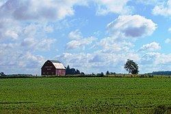
Southwold is a township in Elgin County, in Ontario, Canada, located on the north shore of Lake Erie. It is a rich agricultural zone producing predominantly corn and soybeans. It is part of the London census metropolitan area.
Contents
Map of Southwold, ON, Canada
History
Southwold was named in 1792 after Southwold in Suffolk, England. The municipality was incorporated in 1852.
Shedden's growth occurred when the Canada Southern Railway was built, bypassing Fingal. Later it was joined by the Pere Marquette railway, still further boosting Shedden's importance. Both railways are now defunct. Talbotville is situated at the intersection of highways 3 & 4, two of the oldest roads in the region.
Southwold was the site of the 2006 Shedden massacre.
Economy
The township is home to the Green Lane Landfill site, a large dump recently purchased by the City of Toronto. Waste from Toronto is expected to be shipped to the site in 2010. Southwold was also home of the Ford St. Thomas Assembly plant until its closure in 2011.
Communities
Demographics
Population trend: