
Incorporated (borough) 1831 Zip code 06890 Local time Tuesday 10:04 AM | Settled 1639 Disincorporated 1854 Population 1,585 (2010) Area code 203 | |
 | ||
Weather 6°C, Wind E at 16 km/h, 93% Humidity Restaurants Gray Goose, Artisan, Organika Kitchen, Wafu Asian Bistro, Athena Diner | ||
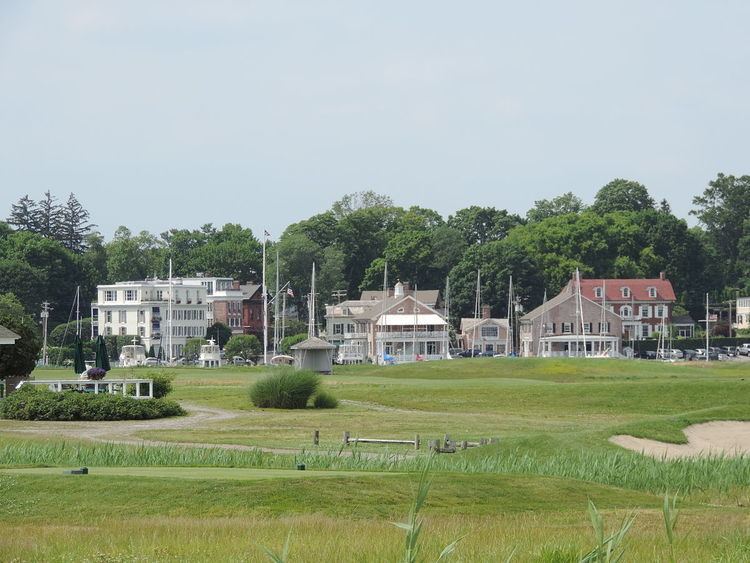
Southport is a former borough in the town of Fairfield, Connecticut, and also a census-designated place. It is located along the Long Island Sound between Mill River and Sasco Brook, where it borders Westport. As of the 2010 census, it had a population of 1,585. Settled in 1639, Southport center has been designated a local historic district since 1967, and was listed on the National Register of Historic Places in 1971 as the Southport Historic District.
Contents
- Map of Southport Fairfield CT 06890 USA
- History
- Demographics
- Public services
- Education
- Transportation
- Notable people
- Movies filmed in Southport
- References
Map of Southport, Fairfield, CT 06890, USA
History
The earliest recorded event in Southport's history was "The Great Swamp Fight" or "Fairfield Swamp Fight" of July 1637 (not to be confused with the later Great Swamp Fight of King Philip's War), an episode of the Pequot War in which English colonial forces led by John Mason and Roger Ludlow vanquished a band of about 80 to 100 Pequot Indians who had earlier fled from their home territory in the Mystic area and had taken refuge with about 200 Sasqua Indians who inhabited the area that is now Fairfield. The exact location of the battle is not known, but it is known to have been in the vicinity of Southport.
In the eighteenth century, Mill River village, a part of Fairfield, was a small hamlet of a few houses and a wharf at the mouth of Fairfield's Mill River. Farm products from the surrounding area were shipped from Mill River's small harbor to ports in New York and beyond.
By 1831 the village had changed its name to Southport and was a bustling commercial area with warehouses, churches, schools, stores and elegant houses. Before 1853, Southport had its own local government as a borough within the town of Fairfield. Southport became a leading coastal port on Long Island Sound, its ships carrying produce and goods back and forth to New York City. A measure of Southport's success is the fact that throughout the 1800s it possessed the only two banks in town. However, competition from steamboats and the railroad took its toll on prosperity. Resourceful shippers teamed with local farmers and businessmen to keep the port going; the Southport onion, a high quality onion, was developed and grown on Fairfield's hills and shipped in Southport market boats, keeping the harbor profitable until the end of the century. In the 1890s, 100,000 barrels of locally grown onions, carrots, potatoes, and other goods were shipped annually from Southport harbor.
Today, much of the old village area is part of a town historic district, first established in 1967, where buildings from three centuries are protected for future generations. The boundaries of the town historic district are the railroad on the north; the Mill River and Southport Harbor on the south; Church Street; and Old South Road and Rose Hill Road on the west and east, respectively, including all properties on both sides of the roads. Strict historic zoning regulations apply in the district and have been upheld by the Connecticut Supreme Court. The Southport Historic District is also listed on the National Register of Historic Places.
Demographics
The main village of Southport corresponds to census tract 606. As of the census of 2000, there are 2,201 people in the village, organized into 998 households and 606 families. The racial makeup of the town is 95.6% White, 2.3% Asian, 0.6% African American, 0.1% Native American, 0.1% Pacific Islander, 0.5% from other races, and 0.7% from two or more races. 1.6% of the population are Hispanic or Latino of any race.
There are 998 households out of which 22.7% have children under the age of 18 living with them, 50.1% are married couples living together, 8.3% have a female householder with no husband present, and 39.3% are non-families. 33.1% of all households are made up of individuals and 15.8% have someone living alone who is 65 years of age or older. The average household size is 2.21 and the average family size is 2.81.
The median income for a household in the village is $140,307, and the median income for a family is $183,023. Males have a median income of $131,695 versus $55,475 for females. The per capita income for the village is $66,432. 2.0% of the population and 1.1% of families are below the poverty line. Out of the total population, 1.5% of those under the age of 18 and 2.7% of those 65 and older are living below the poverty line.
Public services
Southport has had its own firefighting service since 1895. The Southport Fire Department was organized that year as a volunteer fire department after a large arson fire in the village. However, it is also protected by Fairfield Fire Department's Engine 4, out of the Southport Firehouse.
The community's public library is the Pequot Library, housed in a Romanesque building, designed by Robert Robertson and built in 1887, that is a contributing property to the National Register Southport Historic District. The library is reputed to have a large collection of old and rare books. The library's annual summer book sale featured more than 140,000 volumes on sale in 2007.
The neighborhood's ZIP code is 06890, whose scope extends further north from the historic village area to include the Mill Hill area.
Education
Eagle Hill School-Southport, a private day school for children with learning disabilities, has been located since 1985 in the former Pequot School in Southport. The historic school building was earlier acquired by the Southport Conservancy to save it from demolition.
Southport is served by the Fairfield Public Schools. Southport is home to Mill Hill Elementary School, although children in some areas considered part of the Southport neighborhood but outside the census tract attend Timothy Dwight Elementary School. Both Mill Hill and Dwight Schools feed into Roger Ludlowe Middle School, Tomlinson Middle School and Fairfield Ludlowe High School.
Transportation
The main arterial road in the area, the Post Road (US 1), runs through Southport, connecting it to other towns along the Connecticut coast. Interstate 95 also passes through Southport, with two exits located in the neighborhood. Southport is also served by the New Haven Line of the Metro-North Commuter Railroad at Southport Railroad Station, with frequent trains to New Haven and New York City. Limited bus service is provided by the Greater Bridgeport Transit Authority.
Notable people
The following are among the notable people who have lived in Southport: