
 | ||
Sources Blue Ridge Parkway, Black Mountains | ||
Upper south toe river nc trout fishing
The South Toe River ( the name Toe is taken from its original name Estatoe, pronounced 'S - ta - toe', a native American name is associated with the Estatoe trade route leading down from the NC mountains through Brevard where there is a historical plaque with information that affirms the route, on into South Carolina where a village of the same name was located), is a river in Yancey County in Western North Carolina. Over the years due to difficulty in pronouncing the name it was shortened to Toe.
Contents
- Upper south toe river nc trout fishing
- Map of South Toe River South Toe NC USA
- South toe river nc 80 to celo
- References
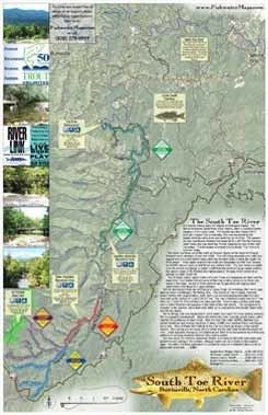
Map of South Toe River, South Toe, NC, USA
It originates in the ravine between the eastern side of the Black Mountains and the Blue Ridge Parkway near the Eastern Continental Divide. It flows alongside North Carolina Highway 80 until it merges with the North Toe River at about 2340' above sea level. The water continues to the Nolichucky River, Tennessee River, Ohio River, and Mississippi River to the Gulf of Mexico. The southern section resembles Peano's Space-filling curve.
Tributaries from the left side include Hemphill Creek, Right Prong South Toe River, Left Prong South Toe River, South Fork Upper Creek, Middle Fork Upper Creek, Grassy Knob Branch, Lower Creek, Camp Creek, Setrock Creek, Little Mountain Creek, Laurel Branch, Middle Creek, Rock Creek, Colbert Creek, Locust Creek, Oak Forest Creek, White Oak Creek, and Brown's Creek. Tributaries on the right side include, Still Fork Creek, Clear Creek, Little Whiteoak Creek, Hannah Branch, Bobs Creek, Phips Branch, Murphy Branch.