
Country United States County Camden GNIS feature ID 1025718 Elevation 4 m Zip code 27976 Local time Monday 10:50 PM | Time zone Eastern (EST) (UTC-5) FIPS code 37-63340 Area 4.641 km² Population 454 (2010) Area code 252 | |
 | ||
Weather 18°C, Wind S at 13 km/h, 68% Humidity | ||
Flooding in south mills north carolina
South Mills is an unincorporated community and census-designated place (CDP) in Camden County, North Carolina, United States. Its population was 454 as of the 2010 census. South Mills has a post office with ZIP code 27976, which opened on March 2, 1840. The community is located near U.S. Route 17, and U.S. Route 17 Business and North Carolina Highway 343 pass through the community.
Contents
Map of South Mills, NC 27976, USA
The community took its name from a watermill which operated near the original town site.
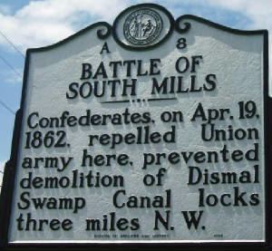
The William Riley Abbott House, Dismal Swamp Canal, and Morgan House are listed on the National Register of Historic Places.
References
South Mills, North Carolina Wikipedia(Text) CC BY-SA