
Population (1999) 367 Area 29.99 km² Mayor Paul Blanc | Region Occitanie Canton Sournia Time zone CET (UTC+1) Local time Monday 5:25 PM | |
 | ||
Weather 13°C, Wind SE at 14 km/h, 63% Humidity | ||
Sournia (Sornian in the Occitan language) is a commune in the Pyrénées-Orientales department in the Occitanie region of south-western France. Its inhabitants are known as Sourniannais.
Contents
Map of 66730 Sournia, France
Geography
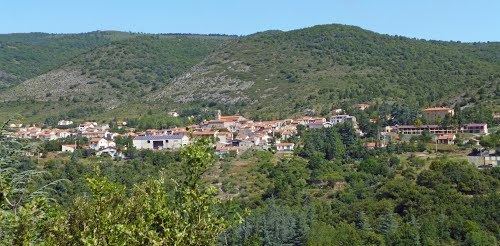
Sournia is a town of the Fenouillèdes, the languedocienne part of the Pyrénées-Orientales, in the canton of Sournia and in the arrondissement of Prades. The river Désix runs through the village. Sournia is 22 km from Ille-sur-Têt and from Vinça, 24 km from Prades and from Saint-Paul-de-Fenouillet, 30 km from Latour-de-France and 34 km from Axat.
The commune is covered by the quality wine standard AOC 'Côtes-du-Roussillon'.
Sournia is crossed by the long distance footpath, GR 36.
Administration
The current mayor of Sournia is Paul Blanc, a senator, of the centre-right and right wing party UMP founded by Jacques Chirac.
Population
The population of Sournia in 2013 was 501 people.
Graph of population change 1794-1999
For some reason at the end of the 19th century, the population of Sournia seemed to have a reputation for having one of the longest longevity in France, even though this fact was not clearly verified.