
Time zone Pacific (PST) (UTC-8) GNIS feature ID 1659818 Elevation 893 m Zip code 95372 Area code 209 | County Tuolumne FIPS code 06-72772 Reference no. 420 Area 7.811 km² Population 2,215 (2010) | |
 | ||
Neighborhoods Chaparral Heights, Monte Grande Heights, Sunshine Camp, Oak Gardens Estates, Willow Springs | ||
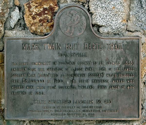
Soulsbyville is an unincorporated census-designated place in Tuolumne County, California, United States. The population was 2,215 at the 2010 census, up from 1,729 at the 2000 census. Formerly a California Gold Rush town, Soulsbyville is now registered as a California Historical Landmark.
Contents
Map of Soulsbyville, CA, USA
Geography
Soulsbyville is located at 37°59′42″N 120°15′37″W (37.994999, -120.260258).
According to the United States Census Bureau, the community has a total area of 3.0 square miles (7.8 km²), 99.80% of it land and 0.20% water.
2010
The 2010 United States Census reported that Soulsbyville had a population of 2,215. The population density was 734.3 per square mile (283.5/km²). The racial makeup of Soulsbyville was 2,038 (92.0%) White, 3 (0.1%) African American, 41 (1.9%) Native American, 13 (0.6%) Asian, 2 (0.1%) Pacific Islander, 38 (1.7%) from other races, and 80 (3.6%) from two or more races. Hispanic or Latino of any race were 206 persons (9.3%).
The Census reported that 2,215 people (100% of the population) lived in households, 0 (0%) lived in non-institutionalized group quarters, and 0 (0%) were institutionalized.
There were 871 households, of which 257 (29.5%) had children under the age of 18 living in them, 488 (56.0%) were opposite-sex married couples living together, 72 (8.3%) had a female householder with no husband present, 41 (4.7%) had a male householder with no wife present. There were 49 (5.6%) unmarried opposite-sex partnerships, and 4 (0.5%) same-sex married couples or partnerships. 200 households (23.0%) were made up of individuals and 82 (9.4%) had someone living alone who was 65 years of age or older. The average household size was 2.54. There were 601 families (69.0% of all households); the average family size was 3.01.
502 people (22.7%) were under the age of 18, 163 people (7.4%) aged 18 to 24, 490 people (22.1%) aged 25 to 44, 710 people (32.1%) aged 45 to 64, and 350 people (15.8%) who were 65 years of age or older. The median age was 42.9 years. For every 100 females there were 101.4 males. For every 100 females age 18 and over, there were 97.6 males.
There were 959 housing units at an average density of 317.9 per square mile (122.8/km²), of which 673 (77.3%) were owner-occupied, and 198 (22.7%) were occupied by renters. The homeowner vacancy rate was 3.0%; the rental vacancy rate was 2.4%. 1,673 people (75.5% of the population) lived in owner-occupied housing units and 542 people (24.5%) lived in rental housing units.
2000
At the 2000 census, there were 1,729 people, 674 households and 485 families residing in the community. The population density was 568.5 per square mile (219.6/km²). There were 725 housing units at an average density of 238.4 per square mile (92.1/km²). The racial makeup of the community was 92.19% White, 2.20% Native American, 0.35% Asian, 0.12% Pacific Islander, 2.95% from other races, and 2.20% from two or more races. Hispanic or Latino of any race were 7.98% of the population.
There were 674 households of which 31.2% had children under the age of 18 living with them, 58.8% were married couples living together, 9.2% had a female householder with no husband present, and 28.0% were non-families. 21.8% of all households were made up of individuals and 9.8% had someone living alone who was 65 years of age or older. The average household size was 2.57 and the average family size was 3.01.
26.5% of the population were under the age of 18, 6.7% from 18 to 24, 24.8% from 25 to 44, 25.3% from 45 to 64, and 16.7% who were 65 years of age or older. The median age was 41 years. For every 100 females there were 102.2 males. For every 100 females age 18 and over, there were 94.2 males.
The median household income was $42,500 and the median family income was $45,625. Males had a median income of $34,516 compared with $18,906 for females. The per capita income for the community was $18,514. About 11.7% of families and 15.6% of the population were below the poverty line, including 25.3% of those under age 18 and none of those age 65 or over.
History
Soulsbyville is named after Ben Soulsby, who resided in the area during the California Gold Rush. Soulsby ran a lumber mill near the intersection of Community Drive and Soulsbyville Road. His contribution to society is forever embossed in the following elementary school song: "Drop on by, we're up the hill. We're the kids from Soulsbyville. See the town with the old saw mill, we're the kids from soulsbyville. Living here is mighty fine, named for Ben Soulsby's old gold mine, come see us, if you will. WE'RE THE KIDS FROM SOULSBYVILLE!".
In January 2007, the visit of a smew, a small diving duck rarely seen in the United States, and only the fourth California state record for the species, brought numerous birders to visit the nearby Willow Springs Pond.
Government
In the California State Legislature, Soulsbyville is in the 8th Senate District, represented by Republican Tom Berryhill, and the 5th Assembly District, represented by Republican Frank Bigelow.
In the United States House of Representatives, Soulsbyville is in California's 4th congressional district, represented by Republican Tom McClintock.