
Length 18.3 km (11.4 mi) | Basin size 120 km (46 sq mi) Bridges Souleuvre Viaduct | |
 | ||
Main source la Lamerie, Montchamp190 m (620 ft) Discharge Average rate:1.57 m/s (55 cu ft/s) (Carville) | ||
La Souleuvre is an 18.3 km long right affluent of the Vire in Normandy.
Contents
- Saut a l elastique le viaduc de la souleuvre normandie david
- GeographyEdit
- WatershedEdit
- CommunesEdit
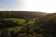
- Souleuvre valleyEdit
- EnvironmentEdit
- References
Saut a l elastique le viaduc de la souleuvre normandie david
GeographyEdit
It crops at Montchamp near the hamlets of Lamerie, la Druerie and la Saffrie, 9 km to the east of Le Bény-Bocage and arrives at Le Tourneur where, having been rejoined by several affluents, it runs along the bed of a steep westwards pictorial valley, formed from the cambrian syncline of la zone bocaine. It lies in the bocage virois.
It joins the Vire, at the northern limit of Carville and Sainte-Marie-Laumont. It then runs westwards through les gorges de la Vire.
WatershedEdit
Its basin lies between those of la Drôme (north), l'Orne (west) and l'Allière (south). Its confluence with the Vire lies west of the basin.
It has 3 main affluents on its right bank: the Blandouit (6,3 km), joined by the Rubec (5.9 km) at Saint-Pierre-Tarentaine the Courbençon (9,5 km) at Tourneur the Roucamps (14,4 km) between Le Tourneur and La Ferrière-Harang.
La Souleuvre and la Vire along with le Rubec and the Blandouit form a digging axe in the bocain syncline shaping a pictural valley ending in les gorges de la Vire.
CommunesEdit
Montchamp, Saint-Charles-de-Percy, Montchauvet, Le Bény-Bocage, Saint-Pierre-Tarentaine, Le Tourneur, Carville, La Ferrière-Harang, Campeaux
Souleuvre valleyEdit
EnvironmentEdit
The Souleuvre basin is a Natura 2000 marked site, namely for its white-clawed crayfish and sculpin population, as well as European brook lamprey and Atlantic salmon.