
Elevation 749 m | ||
 | ||
People also search for Skælingsfjall, Slættaratindur, Kopsenni | ||
Sornfelli faroe islands
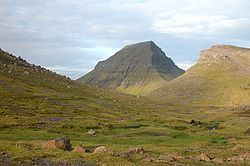
Sornfelli is a mountain plateau on the island of Streymoy in the Faroe Islands about 12 km from the capital Tórshavn (20 km by road). It is the site of a military station at 725 m asl. The Sornfelli Meteorological Station installed in 1999 is located in the middle of the 40000 m2 Sornfelli Mountain top plateau at 725 m asl.
Contents
- Sornfelli faroe islands
- Map of Sornfelli Faroe Islands
- Sornfelli above the top of the mountains in the faroe islands
- References
Map of Sornfelli, Faroe Islands
Temperatures at the meteorological station in 2000 were:
From Tórshavn you can drive over the mountain road "Oyggjarvegin" to the Sornfelli Mountain plateau. There is a public road up to the Sornfelli Mountain plateau, but not the last 200 m to the radar base. The mountain Sornfelli has a height of 749 m.
Sornfelli above the top of the mountains in the faroe islands
References
Sornfelli Wikipedia(Text) CC BY-SA