
Reference no. 203323 | ||
 | ||
Similar Bathampton Down, Twyford Down, Cadbury Castle - Somerset, Beckford's Tower, Royal Victoria Park - Bath | ||
Solsbury hill by peter gabriel in 1080p hd
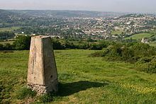
Little Solsbury Hill (more commonly known as Solsbury Hill) is a small flat-topped hill and the site of an Iron Age hill fort. It is located above the village of Batheaston in Somerset, England. The hill rises to 625 feet (191 m) above the River Avon, which is just over 1 mile (2 km) to the south, and gives views of the city of Bath and the surrounding area. It is within the Cotswolds Area of Outstanding Natural Beauty.
Contents
- Solsbury hill by peter gabriel in 1080p hd
- Map of Solsbury Hill Batheaston Bath UK
- Solsbury hill peter gabriel cover
- Etymology
- Geology
- Hill fort
- Later history
- Wildlife
- References
Map of Solsbury Hill, Batheaston, Bath, UK
The hill is one of several possible locations of the Battle of Badon and shows the remains of a medieval field system. In the 19th century part of the hill was quarried. It was acquired by the National Trust in 1930. The hill was the inspiration of the Peter Gabriel song "Solsbury Hill" which was recorded in 1977. A small turf maze was cut into the turf by protesters during the widening of the A46 in 1994.
Solsbury hill peter gabriel cover
Etymology
It is sometimes misspelled as Salisbury, or Solisbury, perhaps because of confusion with Salisbury Plain (a plateau in southern England), or the city of Salisbury. Salisbury and Solsbury can be difficult to distinguish in speech, as Salisbury is often pronounced "Saulsbury" and sometimes the "a" in "Salisbury" is pronounced as an "o", and the "i" is elided, making the pronunciations of the two words practically identical. The name, "Solsbury", may be derived from the Celtic god Sulis, a deity worshipped at the thermal spring in nearby Bath.
Geology
The hill is formed in layers from a variety of sedimentary rocks of Jurassic age. In common with the Cotswold plateau to the north, the summit is formed from rocks ascribed to the Chalfield Oolite Formation. The oolite together with the Fuller's Earth Formation which underlies it, forms a part of the Great Oolite Group of rocks of Bathonian age. Beneath these are, successively, Bajocian age limestones of the Inferior Oolite Group and sandstones of the Bridport Sand Formation. The last-named unit forms a part of the Lias Group of rocks of Toarcian age. Beneath all of these is the relatively thick Charmouth Mudstone Formation sequence rising from the edge of the valley floor alluvium. All faces of the hill are subject to large areas of landslip.
The 625 feet (191 m) high hill is just over 1 mile (2 km) to the north of the River Avon.
Hill fort
Hill forts developed in the Late Bronze and Early Iron Age, roughly the start of the first millennium BC. The reason for their emergence in Britain, and their purpose, has been a subject of debate. It has been argued that they could have been military sites constructed in response to invasion from continental Europe, sites built by invaders, or a military reaction to social tensions caused by an increasing population and consequent pressure on agriculture.
Solsbury hill was an Iron Age hill fort occupied between 300 BC and 100 BC, comprising a triangular area enclosed by a single univallate rampart, faced inside and out with well-built dry stone walls and infilled with rubble. The rampart was 20 feet (6 m) wide and the outer face was at least 12 feet (4 m) high. The top of the hill was cleared down to the bedrock, then substantial huts were built with wattle and daub on a timber-frame. After a period of occupation, some of the huts were burnt down, the rampart was overthrown, and the site was abandoned, never to be reoccupied. This event is probably part of the Belgic invasion of Britain in the early part of the 1st century BC.
Later history
The hill is near the Fosse Way Roman Road as it descends Bannerdown hill into Batheaston on its way to Aquae Sulis. Solsbury Hill is a possible location of the Battle of Badon, fought between the Britons (under the legendary King Arthur) and the Saxons c. 496, mentioned by the chroniclers Gildas and Nennius. The hilltop also shows the remains of a medieval or post medieval field system.
The hill also has two disused quarries, one quarry listed on the North West side on an 1911 map, and another one listed as an old quarry on the West side in 1885–1900. It was acquired by the National Trust in 1930. People protesting against the building of an A46 bypass road cut a small turf maze into the hill, during the construction of the bypass in the mid-1990s. In one day of protests, 11 people, including George Monbiot, were hospitalised as a result of beatings by the security guards.
Wildlife
The plants and animals which live on Solsbury Hill reflect the habitat provided by grassland overlying the limestone rock beneath. Specialist plants and animals, some of which are rare species, have adapted to the calcareous grassland. Most of the landscape is largely unaffected by agriculture as shown by the yellow meadow ant. Examples of plant species found include bird's foot trefoil, vetches, greater knapweed, harebells, yarrow (Achillea millefolium), and scabious. It is one of a series of flower-rich habitats, which Avon Wildlife Trust are trying to link together. The plants attract a range of insects including: the six-spotted burnet moth, hummingbird hawk-moth and a number of butterflies including chalkhill blues. A small population of common buzzard (Buteo buteo) nest in the area. Roe deer (Capreolus capreolus), badger and red fox are also seen. The skylark also nests on the hill.