
 | ||
Solomon Heights is a section of Sunshine North, consisting of 32.8 hectares of land located 10 km from the center of Melbourne. It is bound by Baldwin Avenue, Munro Avenue, Vermont Avenue, and the Melbourne-Sydney railway line, inclusive of the Albion-Jacana railway line. The area of Solomon Heights is significant in its lack of development comparative to adjacent suburbs, despite being subdivided into 435 lots during the 1920s. The area is lacking in sealed roads, drainage and power as of 2013. Numerous reasons are cited for the lack of development activity within the Solomon Heights area, particularly its status as a significant local grassland and infrastructure constraints.
Contents
The area is named after Michael Solomon, who in the 19th century had a sheep station in the area. He was one of the first settlers in Victoria. Soloman's Ford nearby also bears his name, once an important crossing over the Maribyrnong River.
Site history
The site consists of 435 lots amongst 135 land-owners. It was originally zoned for industrial use and development, but development interest was quickly lost due to a number of factors: the lot sizes were not appropriate for most industrial use, whereas those in the adjacent Sunshine North industrial estate were larger.
Despite close proximity to the Western Ring Road, traffic movement is limited by the Albion–Jacana railway line, resulting in the congestion of local connecting roads and access points. This rendered Solomon Heights an undesirable location for an industrial precinct. Many landowners chose to retain their properties, continuing to pay council fees including water rates and municipal charges despite their lots not being serviced. The geology of the area spurred on quarry speculation, with three full-scale quarries and one partial quarry dug for the excavation of rock fragments for gravel. Such activity was undertaken in the 1970s.
Present day
The site has recently been identified as an important "strategic site" within the municipality of Brimbank. It also contains a large number of disused quarries.
Biodiversity
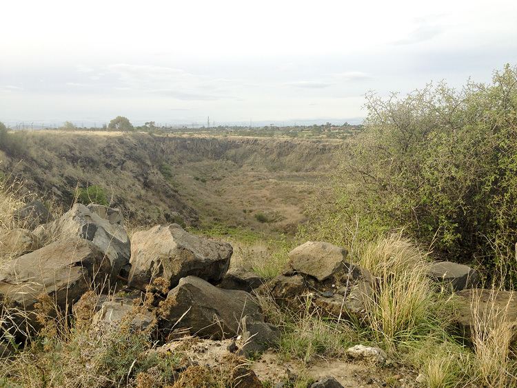
The site contains 14.4 hectares which are considered to be of "state and national significance" due to the presence of several endangered plant species, escarpment scrubland and a river red gum woodland bioregion. This is considered rare in the region of Melbourne, and the site is considered one of the most threatened in the state by housing development.
The site contains 75 specimens of the endangered pimelea spinescens, 2% of remaining population, and is 0.6-0.8% of all remaining basalt plains grassland. The significance of this has resulted in much discourse on the future of the site, with the such as the suggestion of establishing a Western Grassland Reserve to protect native flora and fauna from inappropriate development.
The City of Brimbank is seeking to preserve and enhance biodiversity with an environmental significance overlay, alongside the introduction of a Natural Heritage Policy in Clause 22.06 of the Brimbank Planning Scheme. However, this lies at odds with separate municipal policy decreeing the location an "important strategic site" with potential for mixed use development.
The site is envisioned as an attempt at whole-Council "place based" design, planning and management, with development as a residential or industrial estate with native grassland offset a distinct possibility. Due to the lack of development and isolation, the site is at high risk for vandalism, trail bike riders and illegal dumping, all of which negatively impact the sensitive grasslands - recently, there has been illegal industrial use on the land, potentially damaging fragile native flora.
Infrastructure
Another constraint for development in the precinct is the Albion-Jacana freight loop. This railway line borders the western boundary of Solomon Heights, rendering Bunnett St the only access point to the site, as a bridge is required to allow for the unobstructed movement of rail rolling stock. This is further complicated by the presence of the Somerton Pipeline, which runs alongside the Albion-Jacana railway line. This pipeline carries 85% of the fuel utilised at Tullamarine Airport, from the Altona Mobil refinery to storage in Somerton.
It was built in the late 1970s by VicRail, well after the 1920s subdivision of Solomon Heights. Due to the presence of the Somerton Pipeline, a development plan inclusive of any work or construction on the site, such as an improvement to road infrastructure or alterations to the railway, requires a permit under Schedule 11 of to the Development Plan Overlay. This particularly concerns any infrastructure works such as the Melbourne Airport Rail route, which could render the site more feasible for future development. This important fuel route is a major contributor to the poor local road connectivity to the site.
Future development
Current concerns of these owners lie in the devaluation of their properties resulting from these externalities. The future of a mixed-use estate on the Solomon Heights site is still unclear. Environmental planning controls relative to the site must be resolved in the interests of protecting native grasslands, allowing for the control of environmental threats in view of future development. The site requires a design and planning response which overcomes constraints placed on the site by its location. This should adequately meet the needs of present land-owners and future municipality growth, whilst retaining the fragile grasslands which typify it.