
Country Egypt Area 68 km2 Population 190,132 (2006) | University Sohag University Governor Sohag | |
 | ||
Map of Sohag
Sohag (Arabic: سوهاج, [suːˈhaːdʒ] Sūhāǧ, [soˈhæːɡ] Sohāg), also known as Sawhāj, Suhag and Suhaj, is a city in Egypt that lies on the west bank of the Nile. It has been the capital of Sohag Governorate since 1960. Prior to that, the capital was the city of Girga and the name of the governorate was Girga Governorate. It also included Esna Governorate (nowadays Qena Governorate).
Contents
- Map of Sohag
- Welcome to sohag middle egypt
- Welcome to sohag city
- History
- Geography
- Economy
- Religion
- Mosques
- Churches
- Monasteries
- Temples and cemeteries
- Subdivisions
- Climate
- Language
- Museums
- Bazaars
- Transport
- Education
- University
- Sports
- Notable people
- Nearby attractions
- References
Welcome to sohag middle egypt
Welcome to sohag city
History
Until the 19th century there was only a village located in the area. In 1960, the capital of the Governorate of Girga was transferred from the city of Girga to growing city of Sohag. The name of the governorate was renamed accordingly.
It is unclear how long this site has been inhabited. There are several mummies here that date to Roman times, the village. In Coptic times, there was a community of monks living at the White Monastery in the area.
The 10th of April is the national day of the governorate to celebrate the victory of the Egyptian national resistance troops on the French troops in Johaina Battle in 1799.
Geography
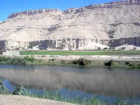
Sohag lies on the western bank of the Nile on a fertile agricultural plain, approximately 6 kilometres (3.7 miles) southwest of Akhmim. In addition, the city includes two islands, Karaman-ez-Zahur Island, which is larger and uninhabited, and ez-Zahur Island (جزيرة الزهور, Ǧazīrat az-Zuhur, "Flower Island") which has some homes.
Economy
The city Sohag of itself encloses only a few archaeological sites, hence tourism represents but a small portion of the city's income. Other sources of income include trade, small industries of carpets, furniture, spinning and weaving and sugar. Administrative and educational services are two big sectors of income.
Religion
Islam is the main religion in Sohag.
Mosques
In the masonry on the east, south and west sides are stones engraved with historic inscriptions moved from previous buildings, including a decree of the penultimate Mamluk sultan al-Ghawri (1441–1516) from the year 1506 (911 AH) on the southeast side.
Churches
In the city there are two important churches erected in the 20th century: the Church of the Holy Virgin and the Church of Saint George.
Monasteries
The Coptic White Monastery is a Coptic Orthodox monastery named after Saint Shenouda the Archimandrite. It is located about 5 kilometres (3.1 miles) west of Sohag. The name of the monastery is derived from the color of the white limestone of its outside walls. The surviving building is the church of what was once a much larger monastery complex.
The Red Monastery is a Coptic Orthodox monastery named after an Egyptian saint called Pishay. It is located about 5 kilometres (3.1 miles) north of the White Monastery. The name of the monastery is derived from the color of the construction material of its outside walls, consisting of red (burnt) brick. These walls are considerably thicker at the base than at the top, and just like the walls of Ancient Egyptian temples, they are surmounted by cavetto moldings. The Red Monastery is architecturally similar to the White Monastery.
Temples and cemeteries
The city is the site of a temple built for the goddess Repyt (Triphis) by Ptolemy XV Caesarion and subsequent Roman emperors. South of this temple was an earlier temple of Ptolemy IX Soter II. One of the tombs nearby, belonging to the brothers Ibpemeny "the younger" and Pemehyt of the late second century BC, has two zodiacs on its ceiling.
Subdivisions
The city of Sohag is informally divided into two division: the East District (Arabic: حى شرق) and the West District (Arabic: حي غرب). Among the most notable regions of the West District are:
The East District is considered a more upscale district that includes some of the most affluent neighborhoods of the city including 15th Street, Al Kashef Street, Jumhuriya Street, The Courts Compound, and The Technical and Agricultural Schools. Some of the most notable locales of the East District include:
Climate
Köppen-Geiger climate classification system classifies its climate as hot desert (BWh). Luxor, Minya, Sohag, Qena and Asyut have the widest difference of temperatures between days and nights of any city in Egypt, with almost 16 °C (29 °F) difference. Sohag is one of the warmest places in Egypt due to its place in the east side of Sahara in North Africa. Sohag is ranked the 5th driest place in Egypt and the 9th globally. Also ranked 4th warmest place in Egypt and 296th globally.
Language
A version of the dialect continuum of Saidi Arabic is spoken by the people of Sohag. However, the most urbanized people may speak to varying degrees Egyptian Arabic.
Museums
The Sohag Museum contains about 5000 artifacts gathered from around the Sohag governorate, including items stretching from the Middle Kingdom to Greco-Roman times.
Bazaars
Souq el-Qisareya: The bazaar in Sohag is named suq Qaiṣarīya, and is partly covered.
Souq el-Itnein: A weekly market held every Monday in the morning for trading in vegetables, fruits, animals and traditional hand made objects (like baskets, farming axes and bags). The weekly market is believed to have been held for the first time during the Ancient Egyptian era. The souq is now in the south of the city and is held in the streets and beside the city cemetery.
Transport
Sohag is linked to Giza and Northern cities through three main roads: road of Asyut Western Desert, Eastern Desert Road, Rural Road also connected to it through the train.
In February 2010 a new highway linking the city to the Red Sea city of Hurghada was opened facilitating the ease the movement between Upper Egypt and the Red Sea coastal region.
In May 2010, the Egyptian Ex-President Hosni Mubarak inaugurated a brand new airport to serve the city called Sohag International Airport.
Education
Sohag is characterized by very large numbers of graduates in all fields.
Illiteracy has continued to drop due to schools (literacy) for all ages free of charge.
There Sohag many schools and colleges most famous:
Primary schools:
Middle schools:
High schools:
University
Sohag University a public university With more than 40,000 students located on the eastern side of the city. It was established under the banner of South Valley University, but became independent in 2006. There are currently ten colleges in Sohag University.
Sports
The most popular sport in Sohag is football. Sohag has many football clubs, including the Egyptian Premier League team Sohag FC. In addition, EPL club El Gouna FC used the Sohag stadium as a home ground at times.
Notable people
Sohag has established a very positive reputation around Egypt, since many important people in Egypt, the Arab world, and the Islamic world came from Sohag.
Nearby attractions
Abydos one of the most ancient cities of Upper Egypt, and also of the eighth Upper Nome of which it was the capital city. It is also considered one of the most important archaeological sites of Ancient Egypt, the sacred city of Abydos was the site of many ancient temples, including a Umm el-Qa'ab, a royal necropolis where early pharaohs were entombed.
Akhmim has several mosques and two Coptic churches, maintains a weekly market, and manufactures cotton goods, notably the blue shirts and check shawls with silk fringes worn by the poorer classes of Egypt.
El-Hawawish the ancient necropolis (cemetery) for the city of Akhmim.
El-Salamuni comprises a rock-cut chapel dedicated to the god Min.
The Meritamen statue in east Akhmim.
Beit Khallaf Outside the village are two very large brick mastabas from the Third Dynasty.
Athribis The city is the site of a temple built for the goddess Repyt (Triphis) by Ptolemy XV Caesarion and subsequent Roman Emperors.