
Pronunciation /snoʊˈkwɑːlmiː/ Elevation 1,914 m | Prominence 304 m | |
 | ||
Easiest route South ridge via Cave Ridge, class 2 Similar Guye Peak, Denny Mountain, Lemah Mountain, Mount Hinman, Chimney Rock | ||
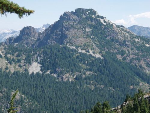
Snoqualmie mountain washington state
Snoqualmie Mountain is the tallest peak in the immediate vicinity of Snoqualmie Pass in the North Cascade Range of Washington state, U.S. Its shape is often described as "amorphous" or "blob-like", although it does display a steep north face dropping down to the Middle Fork of the Snoqualmie River. The boundary of the Alpine Lakes Wilderness crosses the summit of Snoqualmie Mountain.
Contents
- Snoqualmie mountain washington state
- Map of Snoqualmie Mountain Washington 98045 USA
- RoutesEdit
- References
Map of Snoqualmie Mountain, Washington 98045, USA
RoutesEdit
The south ridge, ascending from Cave Ridge between Snoqualmie Peak and Guye Peak, is a non-technical hike. To reach Cave Ridge, either ascend from just south of the Snow Lake trailhead near Alpental to the west, or ascend from the Commonwealth Basin to the east. Expect to take 4 hours to reach the summit. The first recorded ascent was by Albert H. Sylvester in 1897 or 1898.