
Country Ukraine Population 955 Area 219 ha | Elevation 655 m (2,149 ft) | |
 | ||
Smozhe (Ukrainian: Смо́же ) is a village (selo) in Skole Raion, Lviv Oblast, in Western Ukraine. Smozhe is located in the Ukrainian Carpathians within the limits the Eastern Beskids (Skole Beskids) in southern part of the Lviv Oblast in Skole Raion. Local government – Smozhenska village council.
Contents
Map of Smozhe, Lvivska, Ukraine
Geography
The village is located along the highway road Highway M06 (Ukraine) (), on the southern slopes of the ridge Dovzhky (998 – 1056 m). It is 146 kilometres (91 mi) from the city of Lviv, 37 kilometres (23 mi) from Skole, and 123 kilometres (76 mi) from Uzhhorod.
This village is located on the altitude of 845 metres (2,770 ft) above sea level, which forms here the mountain climate.
History
The first written mention of which dates from the year 1553. Later, King Augustus III created the town, giving him October 24, 1760 Magdeburg rights and emblem. In the Geographical Dictionary of the Kingdom of Poland in volume X (released in 1889) description Smozhe occupies three pages. Smozhe was a town with a town hall, several shops and artisan workshops.
Sights
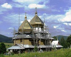
Preserved in the Smozhe a wooden Church of St. Michael, 1874. Together with Belfry located next are under protection of the state.