
Time zone CET (UTC+1) Area code 0117 Local time Friday 11:39 AM | Elevation 2 m (7 ft) Postcode 4500–4519, 4524–4529 Website www.gemeentesluis.nl | |
 | ||
Weather 11°C, Wind E at 24 km/h, 70% Humidity Points of interest Nieuwe Sluis, Bezoekerscentrum 't Zwin, Fishery Museum, Belfort Sluis, Speelboerderij Pierewiet | ||
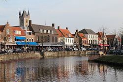
Sluis ( pronunciation ) is the name of both a municipality and a town located in the west of Zeelandic Flanders, in the south-western part of the Netherlands.
Contents
Map of Sluis, Netherlands
The current incarnation of the municipality exists since on 1 January 2003. The former municipalities of Oostburg and Sluis-Aardenburg merged on that date. The latter of these two municipalities was formed from a merger between the previous municipality named Sluis and the former municipality of Aardenburg.
History
The town received city rights in 1290.
In 1340 the Battle of Sluys was fought nearby at sea.
There is a record of one of the first lotteries with money in 9 May, 1455 of 1737 florins ($US 170,000 2014)
During the Eighty Years' War in 1587 the town was captured by Spanish troops under the Duke of Parma and was retaken in 1604 by a Dutch and English force under Maurice of Nassau.
From 2006 until its closure in 2013, Oud Sluis was one of only two Michelin three-starred restaurants in the entire country.
Geography
In addition to the town of Sluis itself, the municipality is made up of the following population centres:
Sint Anna ter Muiden, with a population of only 50 (2001), is a small village about 1 km west of the town of Sluis, located on the westernmost point of the Netherlands.
Demography
The population of the city is 2,040 (as of 2001).
Transport
A ferry connection across the Westerschelde exists between Breskens and Vlissingen. After the opening of the Westerschelde tunnel near Terneuzen in 2003, the ferry now carries only pedestrian and bicycle traffic.