
OSI/OSNI grid S297307 Elevation 721 m Listing Marilyn | Topo map OSi Discovery 67 Prominence 638 m | |
 | ||
Similar Knockmealdown, Galty, Keeper Hill, Fauscoum, Devil's Bit | ||
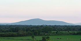
Slievenamon (Irish: Sliabh na mBan, [ˈʃlʲiəw n̪ˠə ˈmˠanˠ], "mountain of the women") is a mountain which is situated northwest of Carrick on Suir and northeast of Clonmel in County Tipperary, Ireland. It stands at 721 m (2,365 ft). Sitting at the western end of a range of low hills, Slievenamon is a striking conical mass, offering a dramatic view from the top over the counties of Tipperary, Kilkenny and Waterford. Much of its lower slopes is wooded. A low hill attached to Slievenamon, known as Carrigmaclea (a.k.a. Carraigmoclear), was the site of a battle during the Irish Rebellion of 1798.
Contents
Map of Slievenamon, Shanbally, Co. Tipperary, Ireland
Etymology
The origin of the mountain's name is explained in Irish mythology. According to the tale, Fionn mac Cumhaill was sought after by many young women, but he said that he could have only one partner. His partner would be whichever woman won a footrace to the top of the mountain. Fionn stood on the cairn atop the mountain and gave a signal to start the race. The winner was Gráinne.
Archaeology
There are two prehistoric cairns on Slievenamon. One is at the very top, and the other is on a lower summit to the northeast known as Sheegouna (from Irish: Sí Ghamhnaí, meaning "fairy mound of the heifers").