
Prominence 245 m (804 ft) Province Connacht Listing Marilyn | Elevation 585 m Easiest route Hiking | |
 | ||
Translation Mountain of the iron (Irish) Similar Knockalongy, Knock - Mayo, Barrclashcame, Barrslievenaroy, Seltannasaggart | ||
Slieve Anierin (Irish: Sliabh an Iarainn, meaning "mountain of the iron") is a large hill in County Leitrim, Ireland. Slieve Anierin was shaped and evolved its present formation by ice age glaciers moving northeast to southwest over millions of years, the Morainic drift heaping up thousands of drumlins in the surrounding lowlands. It is a valuable natural heritage site containing exposed marine and coastal fauna. The mythological "Tuatha De Dannan" are associated with Slieve Anierin.
Contents
- Map of Slieve Anierin Barnameenagh Co Leitrim Ireland
- Etymology
- Natural heritage site
- Geography
- Geology
- Stratum
- Coal field
- Sliabh an Iarainn literary project
- Muintir Eolais lake
- Iron industry
- Cornashamsoge Furnace
- Slieve Anierin Canal
- Drumshanbo Furnace
- Ballinamore Iron works
- Creevlea Iron works
- Swanlinbar Iron works
- Coal industry
- Ancient forest
- Tuatha De Dannan
- Gobn Saor
- Hunger stone
- References
Map of Slieve Anierin, Barnameenagh, Co. Leitrim, Ireland
Etymology
The name Irish: Sliabh an Iarainn, meaning "mountain or moor of the Iron'", originates from an ancient appreciation that Iron ore deposits are present, with Boate (1652) stating "the mountains are so full of this metal, that hereof it hath got in Irish the name of Slew Neren, that is, Mountains of Iron". It was also known as “the mountain of Conmaicne Rein in Connacht".
Natural heritage site
Slieve Anierin is a valuable geological heritage site due to the sequence of Carboniferous faunas it provides, a wide picture of which is accessible without needing borehole cores. An unbroken sequence of marine fossils in the rock layers spans the Namurian (326-315 million years ago) and lower Westphalian (313-304 million years ago) stages of the Silesian (series).
The Geological survey of Ireland (1878) wrote “the Geologist may examine all the formations of the district from the Lower Silurian up to the outlier of Coal-measures that crowns Slieve-an-Ierin… It is a rare thing in most countries to find so much comprised in so small a space”.
Yates (1957) published a study covering over 120 distinct fossiliferous sites on Slieve Anierin, illustrated by many detailed fossil photographs, though she died tragically young before finalizing her research. She reported some rock layers particularly fossiliferous, the shale bands abundant with goniatite faunas and Bivalvia marine and freshwater molluscs. The unfossiliferous shales often contain numerous clay-ironstone bands making conditions intolerable for marine organisms. At most of the fossiliferous levels in the Namurian beds the number of goniatites and Bivalvia are usually very high, with the diversity of species low.
Geography
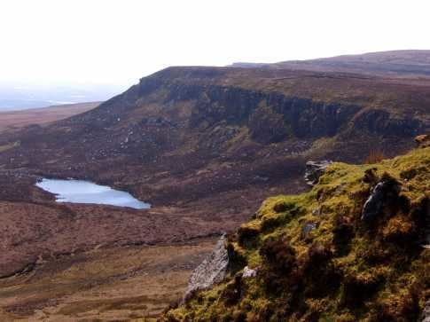
Slieve Anierin is an imposing "mountain" or Marilyn, the highest in county Leitrim, rising from the eastern shore of Lough Allen to a summit elevation of 586-metre (1,923 ft), towering over and dominating the rugged landscape On this summit at 520 metres (1,706.0 ft), a Triangulation station of the Ordnance Survey is fixed on a low concrete plinth.
Geology
Slieve Anierin is composed of Carboniferous shales, and sandstones blanketed by heather-covered moorland, and located in an area of Upper Carboniferous rocks extending from the northern extremity of Lough Erne for about 48 kilometres (29.8 mi) to the southern tip of Lough Allen. Shale is the dominant rock type throughout the Carboniferous succession, but a thick grit, with coal seams, occurs in the lower rock layers of 326-315 million years ago. At its greatest width the outcrop stretches eastwards towards Swanlinbar 32 kilometres (19.9 mi) distant. The outcrop narrows northwards, interrupted by a deep shoreline indentation of Carboniferous Limestone around the Belcoo area, to the north of which it widens before rapidly narrowing towards Lough Erne.
Slieve Anierin, at the southern end of this mass, and east of Lough Allen, is a flat topped mountain with a prominent and steep grit slope, easily mistaken for the summit from a distance, when in fact another 50 metres (164.0 ft) of shales form a small residual outlier overlying this grit. There is a thick obscuring mantle of peat bog and glacial drift below the steep grit slope, with heather and peat bog forming a thick mantle over most of the upland plateau at the summit. Rocks are typically horizontal or gently dipping, except in land-slipped areas. Impressive landslides have occurred along the western face, and at the south-western and south-eastern corners of the mountain, indicating a appreciative magnitude of land-slipping.
Stratum
The geological section from Lough Allen across Slieve Anierin has the following general succession of strata-
The so-called "Yoredale beds" extend down to the edge of Lough Allen on the west, and to the top of the Carboniferous Limestone on the south and south-east. At the base of the succession occur limestones, calcareous mudstones, and sandstones, but from the base of the Namurian upwards shales are continuous until the millstone grit horizon.
Coal field
Slieve Anierin is the most eastern part of the Connacht coal field. Well-marked escarpment lines are visible, partly exposed by lines of geological fault on all sides of the mountain valleys, the collapsed layers removed by denudation. The outcrop of two coal seams, crow coals with a sandstone roof and middle coal under a slate roof, are traceable some difficulty along the grit escarpment on the western side of Slieve Anierin towards the Stony River valley, becoming completely obscured by drift deposits on the southern flanks, and on the eastern flanks to a mile North of Lough Nabellbeg continuing through the townlands of Sradrinagh and Cornamucklagh South obscured by a thick blanket of peat bog, becoming visible again further north on the western side of the hill at Cleighran More and Cleighran Beg where faults are evident. The outcrop of both coal seams is also traceable for 0.8 kilometres (0.5 mi) along the south-eastern slopes of Bencroy. More than two coal seams may be present at Slieve Anierin, though the only rocks observable over the coal seams (in the millstone grit) are the lower coal measure containing black and brown splintery shales of a considerable thickness at Bencroy to the east and Barnameenagh to the west.
Sliabh-an-Iarainn literary project
The 'Sliabh an Iarainn project is a literary initiative started in 2004 to write about the history of the people who inhabited the necklace of town lands on the flanks of Sliabh-an-Iarainn and Ben Croy, in county Leitrim. The goal was to preserve a memory of the Ultachs, Catholic refugees displaced out of Ulster in 1795 who made a home on the mountain, their experiences of famine and emigration, and the resilience of the remaining communities. This Slieve Anierin social history was released in three volumes-
Muintir-Eolais lake
In the remote mountainous Cuilcagh-Anierin uplands, an oligotrophic lake called "Lough Munter Eolas" named after the chieftain Eolais Mac Biobhsach and his Muintir Eolais descendents, straddles the border of Moneensauran townland in west Cavan, and Slievenakilla townland in south Leitrim.
Iron industry
Iron Ore has been dug at Slieve Anierin for millennia, the Ore rather tough like Spanish Iron. Evidence that Iron Age tools and weapons were being molded from Iron ore has been found at Lough Scur. Commercial Iron works existed around Slieve Anierin c. 1630, and though nearly all were destroyed during the Irish Rebellion of 1641, they were revived after the Irish Confederate Wars. The siting of Smelting works contiguous to Lough Allen allowed for the transportation of Pig Iron in boats of up to forty tons. Commercial iron mining declined after c. 1750 – c. 1760 as deforestation exhausted the fuel for burning charcoal.
Cornashamsoge Furnace
In the 17th century the Cornashamsoge smelting works founded. Local tradition says "about the year 1650, there was a furnace for smelting Iron ore in the downland of Cornashameogue, situated on the east side of Lough Allen. The site of the furnace can still be pointed out, and the field in which it is situated has got the name of the Furnace Meadow". Cornashameogue is overlooked by the adjacent townland of Irish: Barnameenagh West, meaning "top of the mines".
Slieve Anierin Canal
Local folklore recalls a so-called "Slieve Anierin Canal" connected with Cornashamsoge smelting works- "the ore had to be conveyed to the furnace for a distance of about 3 miles. For this purpose a canal was made. The canal ran by the foot of the mountain. Several rivers flow westward from the mountain into Lough Allen. The largest of these is the stoney river, a river that becomes a roaring torrent in times of heavy rain, often overflowing its banks, and causing great destruction, to lands, crops and houses. Build the time mentioned above, about the year 1650. The water of the stoney river was diverted into the canal. The canal then was fed principally by this river, and in a lesser degree by the other smaller rivers that ran in the same direction. All the rivers ran at right angles to the canal. The water also supplied the power that worked the furnace. As to the Slieve an Iren [Anerin] canal, there are but very meagre traces of it at the present time".
Drumshanbo Furnace
After the ironstone melted, the Pig iron was brought to Drumshanbo Finery forge to the south of Lough Allen to produce the malleable iron product which was transported to Dublin and Limerick by boat. Folklore claims the "Iron ore was conveyed to the Drumshanbo furnaces by boat, on Lough Allen. The sources of supply, were, the Slieven an Iern [Anerin], Ballinaglera, Arigna mountains, all situated around Lough Allen. It is thought that the town of Drumshanbo had its origin in these industries".
Ballinamore Iron works
Ballinamore Iron works was established sometime after 1693 and continued production until probably 1747 when the business was put up for sale, the assets including a furnace, forge, slitting mill, mine yards, coal yards, large quantities of pig iron, mine and coals.
Creevlea Iron works
The last Iron works in Ireland, located at Creevelea in county Leitrim ceased production in 1858, and later attempts to revive the industry here were complete failures.
Swanlinbar Iron works
There was a long established Iron works at Swanlinbar in county Cavan, at the far north-east corner of Slieve Anierin.
Coal industry
In 1957, an attempt to mine the lower 1.1 metres (3 ft 7.3 in) thick coal-seam located about 366 metres (1,200.8 ft) west of the Rocking Stone ("Fionn MacCumhaill’s Rock") was abandoned, the coal being poor quality and seams non persistent. On the eastern side of Slieve Anierin there is another abandoned level in the upper seam which is 0.3 metres (11.8 in) thick, the location possibly being above Aughacashel House.
Ancient forest
Long ago Ireland had been covered in Woodland, a claim echoed by a 19th century survey of Leitrim- “A hundred years ago almost the whole country was one continued, undivided forest, so that from Drumshanbo to Drumkeeran, a distance of nine or ten miles, one could travel the whole way from tree to tree by branches". These great forests in Leitrim and on the west side of Lough Allen were denuded for the making for Charcoal for Iron works around Slieve Anierin. Immense piles of cleared timber existed at Drumshanbo in 1782.
Tuatha De Dannan
The Book of Invasions describes the Tuatha Dé Danann, tribe of the goddess Danu" arriving in Mesolithic Ireland through the air before landing their floating-ships on the summit of Slieve Anierin, "the mountain of Conmaicne Rein in Connacht". The men included Nuada the king, Manannan the powerful, Neit the battle god, and Goibniu the Smith. The women included Badb the battle goddess, Eadon the poets nurse, Brigit a goddess, and Dagna the goddess mother. Messengers informed Eochaid son of Ere, and king of the Fir Bolg, that a new race of people had settled in Ireland. The Firbolgs sent forward their champion Sreng to see the strangers, and the Tuatha De Danann getting sight of his approach sent their champion Bres to meet and talk with him. The two champions met at Magh Rein near Slieve Anierin but no peace was concluded. The Tuatha Dé Danann advanced further west into Connacht and defeated the Firbolg at the first Battle of Moytura, but three centuries later settled in the Celtic Otherworld on being displaced by the Milesians, mythological ancestors of the present Irish.
Gobán Saor
Metal workers were held in high esteem, and the Irish Pantheon Gobán Saor is synonymous with the legendary Scandinavian named Vaeland Smith and Goibniu of the Tuatha De Dannan. Gobán Saor supposedly worked certain mines on Slieve Anerin.
Hunger stone
Long ago in the parish of Kiltubrid the term Irish: fear gorta (“hungry man”) was applied to a hunger which supposedly may inflict a person on the mountains, proving fatal if not quickly satisfied. This hunger immediately affected any person who walked on a legendary “fear-gorta (hungry-man) stone” at the base of Slieve Anierin.