
Width 2.5 km (1.55 mi) Highest point Skattørfjellet Elevation 345 m Municipality Skjervøy | Length 7 km (4.3 mi) Highest elevation 345 m (1,132 ft) Area 11.73 km² | |
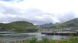 | ||
Skjervøya (Northern Sami: Skiervá) is an island in the municipality of Skjervøy in Troms county, Norway. The island lies to the east of the island of Kågen and south of Laukøya. The Kvænangen fjord lies to the east of the island. The village of Skjervøy is the main population centre on the 11.7-square-kilometre (4.5 sq mi) island. Fishing is one of the main industries on the island. Skjervøya is connected to the mainland by a bridge and then a tunnel. The Skjervøy Bridge connects the island to Kågen island to the west. The undersea Maursund Tunnel the connects Kågen to the mainland.
Map of Skjerv%C3%B8ya, 9180 Skjerv%C3%B8y, Norway
References
Skjervøya Wikipedia(Text) CC BY-SA