
Elevation 1,848 m Mountain range Breheimen | Prominence 330 m Parent range Breheimen | |
 | ||
Location Stryn, Sogn og Fjordane, Norway Topo map 1318 I Stryn (west) and
1418 IV Lodalskåpa (east) Similar Lodalskåpa, Slogen, Fannaråki, Ramnefjellet, Galdhøpiggen | ||
Skåla is a mountain in the municipality of Stryn in Sogn og Fjordane county, Norway. The mountain is located about 7 kilometres (4.3 mi) east of the village of Loen and about 7 kilometres (4.3 mi) south of the lake Oppstrynsvatn. There are two summits to the mountain, one at 1,843 metres (6,047 ft) and one at 1,848 metres (6,063 ft) above sea level. The latter one is sometimes called Stryneskåla. Every year there is a race from the village of Loen up the mountain.
Contents
Map of Sk%C3%A5la, 6789 Loen, Norway
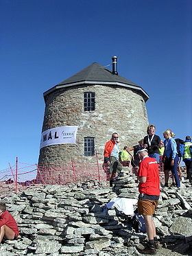
Skålatårnet/Kloumantårnet
The tower at the top of the 1843 m. summit is built from rocks. It is called Skålatårnet ("Skåla tower") or Kloumantårnet ("Klouman tower"). The construction of the tower was initiated by Doctor Hans Henrik Gerhard Klouman from the nearby village of Innvik. It was built as a means to cure tuberculosis, which was widespread in the late 19th century. The walls in the tower are 50 centimetres (20 in) wide, and there are two floors. Today, the tower is accessible to the public, with 22 beds. It is administered by Bergen Turlag, a subsidiary of the Norwegian Trekking Association.
Name
The name of the mountain is the finite form of skål which means "scale" or "bowl". In the hillside that faces the lake Strynsvatnet has a large depression in it which is shaped like a bowl.
Skiing
Skåla is one of the best backcountry skiing mountains in Norway. The trail up is also possible to reach during the winter. It takes about five hours to reach the top and gives you a downhill experience to remember.