
Elevation 1,070 m (3,510 ft) Postal code 26xxx Area 2,987 km² Area code 0222 | Region Central Anatolia Time zone EET (UTC+2) Licence plate 26 Local time Thursday 9:29 AM | |
 | ||
Weather 5°C, Wind E at 5 km/h, 51% Humidity | ||
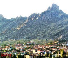
Sivrihisar (Turkish: Sivrihisar, "a pointed castle") is a town and district of Eskişehir Province in the Central Anatolia region of Turkey. According to 2010 census, population of the district is 23 488 of which 9,817 live in the town of Sivrihisar. The district covers an area of 2,987 km2 (1,153 sq mi), and the average elevation is 1,070 m (3,510 ft).
Contents
- Map of Sivrihisar 26600 Sivrihisar2FEskiC59Fehir Province Turkey
- Location
- Economy
- Notable natives
- References
Map of Sivrihisar, 26600 Sivrihisar%2FEski%C5%9Fehir Province, Turkey
Location
The town of Sivrihisar lies 13 km (8.1 mi) north of the historical site of Pessinus, at the foot of a high double-peaked ridge of granite, which bears the ruins of a Byzantine castle, and gives the town its name (sivri "sharp, pointed", hisar "fortress, castle"). It is located at the intersection of the E-90 and E-96 routes.
Economy
As of 1920, Sivrihisar was producing knitting clothing.
Notable natives
References
Sivrihisar Wikipedia(Text) CC BY-SA