
Highest elevation 1,540 m (5,050 ft) Elevation 1,540 m | Population 0 Area 227.6 km² | |
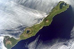 | ||
simushir island
Simushir (Russian: Симушир, Japanese: 新知島, Shimushiru-tō, Ainu: シムシㇼ, Simusir), meaning Large Island in Ainu, is an uninhabited volcanic island near the center of the Kuril Islands chain in the Sea of Okhotsk in the northwest Pacific Ocean. It was formerly known as Marikan.
Contents
- simushir island
- Map of Simushir Sakhalin Oblast Russia 694550
- Simushir off the west coast of haida gwaii
- History
- Geology
- Climate
- Fauna
- References
Map of Simushir, Sakhalin Oblast, Russia, 694550
Simushir off the west coast of haida gwaii
History
At the time of European contact, Simushir was inhabited by the Ainu. The island appears on an official map showing the territories of Matsumae Domain, a feudal domain of Edo period Japan dated 1644, and these holdings were officially confirmed by the Tokugawa shogunate in 1715. Russian explorer Gerasim Izmailov was marooned on Simushir in the early 1770s. He spent a full year subsisting on "scallops, grass, and roots". Sovereignty initially passed to Russia under the terms of the Treaty of Shimoda, but was returned to the Empire of Japan per the Treaty of Saint Petersburg along with the rest of the Kuril islands. The island was formerly administered as part of Shimushiru District of Nemuro Subprefecture of Hokkaidō. Settlers on the island were engaged in fishing, and the raising of Arctic fox and reindeer. During World War II, the civilian population was evacuated to the Japanese home islands and Simushir was garrisoned by a detachment from the Imperial Japanese Army. It was surrendered to Soviet forces during the Battle of the Kuril Islands without resistance.
Under the Soviet Union, Brouton Bay was used by the Soviet Navy as a secret submarine base between 1987 and 1994, and had a population of approximately 3000 people. The remains of the base can be seen clearly on satellite images.
Today the island is uninhabited. It is now administered as part of the Sakhalin Oblast of the Russian Federation.
Geology
Simushir is highly elongated, consisting of a series of stratovolcanos. The island has a length of 59 kilometres (37 mi) with a width of 13 kilometres (8.1 mi), and an area of 227.6 square kilometres (87.9 sq mi). At the north end of the island is a half-submerged caldera, Brouton Bay, with an entrance only 2.5 meters deep, plunging to 240 meters in the center.
Climate
In spite of its temperate latitude, the powerful Oyashio Current on the western flank of the Aleutian Low gives Simushir a chilly and very wet subarctic climate (Köppen Dfc) that amazingly almost qualifies as a polar climate (ET), which in low-lying areas would be expected only at latitudes about 20 degrees or 2,200 kilometres (1,370 mi) further north. Unlike typical subarctic or polar climates, however, the winters are only moderately severe and there is no permafrost since the mean annual temperature is around 2.8 °C (37.0 °F), whilst temperatures have never fallen below −22.2 °C (−8 °F). However, the extreme winds, which in winter average as much as 43 kilometres per hour (27 mph), make it feel much colder. Summers are mild, but extraordinarily cloudy with fogs occurring on six-sevenths of all days in summer and annual sunshine hours less than 1,100 per year, which is comparable to Reykjavík or the extremely foggy Sichuan Basin. Sunshine is actually most likely in the wettest months of September and October when the heavy rain removes the low-level fog, but clear days are extremely rare at any time of year.
Fauna
In the spring crested and least auklet, Leach's storm petrel, and Japanese cormorant nest on the island.