
- elevation 4,150 ft (1,265 m) Length 153 km Basin area 3,297 km² | - elevation 5,598 ft (1,706 m) - average 185 cu ft/s (5 m/s) Basin area 3,297 km² Source Aldrich Mountains | |
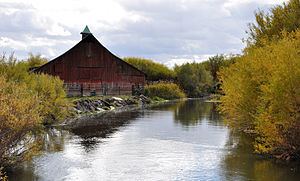 | ||
The Silvies River flows for about 119 miles (192 km) through Grant and Harney counties in the U.S. state of Oregon. The river drains 1,273 square miles (3,300 km2) of the northern Harney Basin.
Contents
Map of Silvies River, Oregon, USA
The headwaters are on the southern flank of the Aldrich Mountains, about 10 miles (16 km) south of Mount Vernon in Grant County. Named tributaries include Bear Creek and Emigrant Creek. The Silvies runs generally southward and passes near Seneca and Burns. Southeast of Burns, in Harney County, the river splits into two distributaries, the East Fork Silvies River and the West Fork Silvies River. Both terminate at Malheur Lake about 25 miles (40 km) southeast of Burns.
Flowing mainly through private land with limited public access, the river supports populations of redband trout, especially on its upstream reaches. Downstream of Seneca, fish such as smallmouth bass, yellow perch, and carp are more abundant. The pool behind Five-Mile Dam, about 5 miles (8 km) north of Burns, is used for swimming, canoeing, and fishing.