
Elevation 4,261 ft (1,299 m) | Width 5 mi (8.0 km) | |
 | ||
Length 6 mi (9.7 km) N-NW x SE Similar Sierrita Mountains, Growler Mountains, Baboquivari Peak Wilderness, New Water Mountains, Tortolita Mountains | ||
The Silver Bell Mountains are an arid north-northwest x southeast trending small mountain range in north-central Pima County, Arizona. The range lies 14 miles (23 km) west of Marana, Arizona, located on Interstate-10, northwest of Tucson.
Contents
Map of Silver Bell Mountains, Arizona 85653, USA
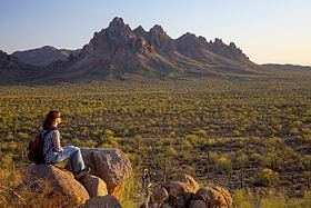
The range is located in the east of the Ironwood Forest National Monument, and is located in a group of four mountain ranges. Ragged Top, located in the north of the range, is a well-known landmark, as good roads extend through this sightseeing and former mining region.
DescriptionEdit
The range is named for the Silver Bell Mine located at the southern end of the mountains. The range abuts the Waterman Mountains to the southeast, where palynology-(pollen) studies have shown some of the recent floristic history of Arizona during the Pliocene. Both ranges lie in the northeast Sonoran Desert; the Madrean Sky Island ranges begin just southeast of here, with the large, and most western sky island range, the Baboquivari Mountains-Quinlans 20-35 mi south.
The Silver Bell range can be accessed by Avra Valley Rd and Silver Bell Rd from the south of Marana.
ClimateEdit
Climate type is characterized by extremely variable temperature conditions. The Köppen Climate Classification sub-type for this climate is "Bsh" (Mid-Latitude Steppe and Desert Climate).