
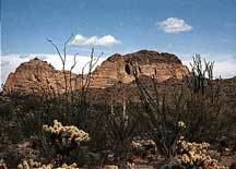
Peak Black Mesa (New Water) Country United States of America | Elevation 3,639 ft (1,109 m) | |
 | ||
Similar Plomosa Mountains, Harcuvar Mountains, Castle Dome Mountains, Trigo Mountains, Dome Rock Mountains | ||
The New Water Mountains is a mountain range in southwestern Arizona. The range is on the northern border of the Kofa National Wildlife Refuge as well as the northern Kofa Mountains.
Map of New Water Mountains, Arizona 85346, USA
It is a northwest-southeast trending range, about 20 miles long. The southeast third of the range is in the Kofa Refuge, and the mountain range merges northwesterly into the Plomosa Mountains of southern La Paz County. The central part of the range is the New Water Mountains Wilderness with a lengthy east-west border on the northern Kofa National Wildlife Refuge of about 12 miles. The highest point is Black Mesa at 3,639 feet (1,109 m).
Three northerly routes access the mountain range; the central route accesses the Ramsey Mine and eventually the central dry wash on the north; other mines are in these mountains-(the Republic Mine), as well as some springs-(Dripping Spring); also Brintley Well on a fourth westerly access route. The closest community to the north side of the mountain range is Brenda, Arizona east of Quartzsite. Brenda is on US 60 4 mi northeast of Interstate 10.