
Highest elevation 214 m (702 ft) Population 5.238 (2010) | Area 1,160 ha (2,900 acres) Elevation 214 m | |
 | ||
Barangays | ||
Sicogon island philippines
Sicogon is an island in northern Iloilo, which is part of the municipality of Carles, Iloilo, Philippines. It is named after cogon, a type of grass found in abundance on the island. According to the 2010 census, it has a population of 5,238.
Contents
- Sicogon island philippines
- Map of Sicogon Carles Iloilo Philippines
- Carles iloilo higantes island diving beach isla de gigantes gopro 1080 cabugao sicogon tangke
- History
- Modern development
- Typhoon Haiyan
- Location and geography
- Barangays
- Air
- Boat
- References
Map of Sicogon, Carles, Iloilo, Philippines
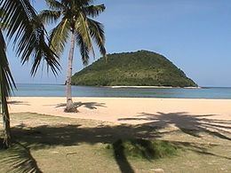
Sicogon was a popular tourist destination during the 1970s, famous for its crystal clear waters and long stretch of white sand beach lined with coconut trees. However, due to the situation caused by martial law, development stalled and Sicogon's popularity faded in favor of Boracay Island.
Carles iloilo higantes island diving beach isla de gigantes gopro 1080 cabugao sicogon tangke
History
Sicogon Island was declared a tourist destination zone by former President Ferdinand Marcos in 1976.
Modern development
On June 2012, a municipal ordinance that declared Sicogon Island as a tourist destination was recognized by the Sanggunian Panllawigan (SP) of Iloilo Province. The declaration aims to revive the island as a tourist destination and to open it for commercial use.
A P10-billion development project was launched on May 9, 2013 by the Sicogon Development Corporation (SIDECO), with the intent of reviving Sicogon as a world-class tourist destination. The project included constructing a five-star hotel and resort, seaport and an airport on the existing airstrip. This plan was not without controversy, as locals clashed with the developer, causing the town of Carles to send an eight-member police force to mediate between the developer, who claimed that residents had agreed to be relocated voluntarily, and residents who said the developer was forcing them off of public lands. On 8 November 2014 a pact was signed between SIDECO and local residents to begin development, with the goal of transforming Sicogon into an ecotourism destination.
Typhoon Haiyan
Typhoon Haiyan passed over Sicogon Island (along with the rest of Panay) on November 8, 2013, damaging fishing boats and nets. Canadian Air Force troops arrived on Sicogon on November 26, bringing medical supplies to the islanders, many of whom were suffering from coughs and colds.
Location and geography
Sicogon is 0.5 miles (0.80 km) southeast from Calagna-an Island. Other nearby islands include Canas Island in the north, Balbagon Island in the east and Panay Island in the west. Tumaguin Island is accessible by foot from Sicogon during low tide. East of the islands is the Visayan Sea, which is a rich fishing ground and source of livelihood for people living in the region. Sicogon's highest point is Mt. Opao, north-east of barangay Buaya, at 214 metres (702 ft). The summit is accessible by trekking and on the summit the entire coastline that surrounds the island can be seen.
Barangays
Sicogon consists of the following three barangays:
Air
The Sicogon Airport (IATA Code: ICO) is a defunct airstrip. It is located in Barangay San Fernando.
Boat
Boats can be chartered from Estancia for less than 2,000 pesos. A public passenger boat leaves from Estancia port normally once daily, at 1 pm. The trip from Estancia to Sicogon takes roughly 45 minutes.