
- elevation 540 m (1,772 ft) Area 802 km² Settlements Church Stretton, Clun | - location Craven Arms Phone +44 1743 254740 | |
 | ||
Address 9, Drovers House, The Auction Yard, Craven Arms SY7 9BZ, United Kingdom Hours Closed today SundayClosedMonday9AM–5PMTuesday9AM–5PMWednesday9AM–5PMThursday9AM–5PMFriday9AM–5PMSaturdayClosedSuggest an edit Similar Long Mynd, Stiperstones, Carding Mill Valley and the L, Caer Caradoc, Clee Hills Profiles | ||
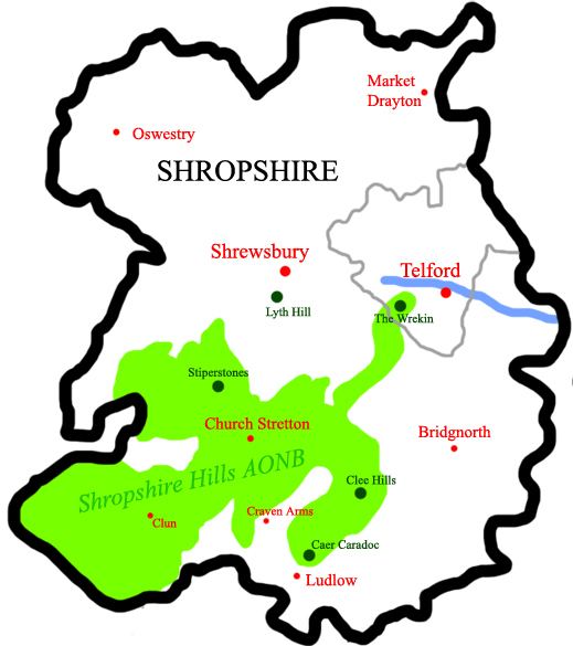
The Shropshire Hills area, in the English county of Shropshire, is designated as an Area of Outstanding Natural Beauty (AONB). It is located in the south of the county, extending to its border with Wales. Designated in 1958, the area encompasses 802 square kilometres (310 sq mi) of land primarily in south-west Shropshire, taking its name from the upland region of the Shropshire Hills. The A49 road and Welsh Marches Railway Line bisect the area north-south, passing through or near Shrewsbury, Church Stretton, Craven Arms and Ludlow.
Contents
Hills
The Shropshire Hills, located in the Welsh Marches, are relatively high: the highest point in the county, Brown Clee Hill, near Ludlow, has an altitude of 540 metres (1,772 ft). This gives Shropshire the 13th tallest hill per county in England. Titterstone Clee Hill, part of the Clee Hills, is nearly as high as Brown Clee, at 533 metres (1,749 ft), making it the third largest hill in the county. The Stiperstones are the second highest, at 536 metres (1,759 ft), and are notable for their tors of quartzite; particularly notable are Devil's Chair (SO368991) and Shepherd's Rock (SO373998).
More accessible hills are the Long Mynd, which covers an area of 5,436 acres (22.0 km2) and peaks at Pole Bank at a height of 516 metres (1,693 feet), is near Church Stretton. It includes Carding Mill Valley, a popular recreational area which was developed as a honeypot to draw tourists away from the more sensitive/protected areas of the Mynd. The Wrekin (407 metres (1,335 ft)), located in the far northeastern panhandle of the AONB, is an extremely popular hill with a well-used trail. Located near Wellington, its position close to the major population centres of Shropshire, and good transport links (A5/M54) make it easy to access. Ercall Hill, a notable geological site, is located just to the north of The Wrekin.
Another prominent hill is Corndon Hill, whose summit is in Wales.
Towns and villages
The largest town in the AONB is Church Stretton (sometimes known as "Little Switzerland"), with a population of about 3,000. The only other town within the boundaries of the AONB is Clun, with fewer than 1,000 people, in the Clun Valley.
Ludlow, the largest town in South Shropshire, lies just south of the AONB. The Shropshire Hills AONB Partnership is based at Craven Arms, just outside the development restriction boundaries. Bishop's Castle is a small town of about 1,500 people, located near the Welsh border to the west. Bucknell is a notable village in the south. Knighton is across the River Teme in Wales, but its station is within the Shropshire Hills AONB.
Local Authorities
The AONB falls largely within the Shropshire Council area. Its northeasternmost extremity, in the vicinity of the prominent Wrekin hill, is located in the borough of Telford & Wrekin.
Rivers
Historical Attractions
Attractions of historical interest located within or near the AONB include Stokesay Castle (near Craven Arms), a well-preserved fortified manor house.
Ludlow Castle in Ludlow was constructed in the 11th Century as the border stronghold of one of the Marcher Lords, Roger de Lacy.
Offa's Dyke, a massive linear earthwork, also runs through the area, and across the Clun Valley area.
Clun Castle is located near Clun.