
OS grid reference TQ765925 Local time Sunday 7:39 AM District Borough of Basildon | Sovereign state United Kingdom Postcode district SS11 Dialling code 01268 | |
 | ||
Weather 7°C, Wind NW at 8 km/h, 89% Humidity | ||
4 bedroom semi detached for sale on wickford essex shotgate ss11 8fx by abbotts countrywide
Shotgate is a civil parish and village in Essex, England. On 1 April 2007, Shotgate became the first area of Wickford to have a Parish Council.
Contents
- 4 bedroom semi detached for sale on wickford essex shotgate ss11 8fx by abbotts countrywide
- Map of Shotgate Wickford UK
- 3 bedroom semi detached for sale on wickford essex shotgate ss11 8xq by abbotts countrywide
- A Brief History of Shotgate
- Shotgate sign
- Community hall
- Nature reserves
- References
Map of Shotgate, Wickford, UK
3 bedroom semi detached for sale on wickford essex shotgate ss11 8xq by abbotts countrywide
A Brief History of Shotgate
Mid-Iron Age pottery found at Shotgate Farm shows that the area was inhabited in 300 BC. In Roman times, a road ran from Ilford to Latchingdon through here. In the Saxon period commonhold land was often sliced into parallel strips known as 'Sceats'. This is the origin of the 'Shot' part of Shotgate, which has nothing to do with shooting or hunting. The Domesday Book of 1086 lists four farmsteads in Wickford, one of which was probably on the site of Shotgate. By 1300 this is listed as Ames or Aimes Farm. By 1540 the Rede family owned the farm, and one of its members, Elizabeth, emigrated to America to marry the son of the governor of Massachusetts, and is an ancestor of both former US president George W. Bush and presidential contender John Kerry. In 1663, Turnpike (Toll) roads appeared in England, and one ran from Shenfield to Rayleigh until 1866 along the Old Southend Road, after which it was turned over to the Rochford Highway Board. During this period (1747), the Sharpe family renamed the Ames Farm as Shotgate Farm. Perhaps this indicated the existence of a tollgate at the Wickford / Rawreth boundary. During this period an inn, the King's Head, stood near present-day Oak Avenue. In 1907, houses were built as part of the `Plotlands' initiative in Enfield Road and Oak Avenue. In 1921, the Archer family bought Shot Farm, and in 1927 sold land for development. This led to the foundation of modern-day Shotgate, consisting of Bruce Grove, 1st to 5th avenues and the shopping parades. In 1989, the village was greatly expanded by the Hodgsons Way Industrial Estate and housing estates, so named after the WW2 RAF Pilot Officer William Henry Hodgson, who was shot down but managed to ditch his Hurricane aircraft, avoiding the houses of the Shotgate estate.
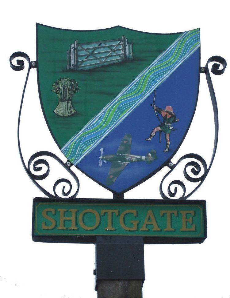
Shotgate sign
The sign is located next to the Southend Road (A129), it is made up of various symbols; Gate, Wheatsheaf, Archer, River, Hurricane.
Community hall
Before the idea for a community hall had been conceived, many different groups were meeting on a regular basis in Shotgate. These included:
Amongst the groups it was decided that a communal building would be needed for the village. A committee was formed and started to raise funds. This included a weekly collection of 6d (2½p) from each household, as well as from fetes and waste paper collections.
A plot of land in Bruce Grove was to be auctioned in 1952 and a request was made to the Urban District Council to reserve it for the committees. The land was purchased for £325.00 in 1955. A building sub-committee was formed to facilitate the building works. The hall was opened, free of debt, on Saturday 8 November 1958 by councillor Tanswell, the then Chairman of Basildon Council.
Some of the materials used in the construction of the building were reclaimed such as the wooden wall panelling which was from a public house in the East End of London and the flooring was from American pre-fabricated buildings. The doors came from Fred's Scrap Yard (now known as Fred's (F.H. Ives) Timber Yard).
The committee raised £1200, and with further grants from the Ministry of Education (United Kingdom) for £1218 a grand total of £2418 was reached. The hall would have cost more than this to construct had it not have been for the free labour given by local volunteers.
The hall has been extended and refurbished several times since being built originally with the most recent being in 2007 when a disabled toilet was added.
The hall is, to this day, still free from debt. It is run by the Shotgate Community Association and funded by the monies raised from hiring out the hall, membership fees and donations. It is not subsidised by the council or any other organisation.
Nature reserves
There are two adjoining nature reserves. Shotgate Thickets form the northern part of this reserve, which is owned by the Essex Wildlife Trust. The southern part of the reserve is owned by Basildon Borough Council and is named Giddings Copse, in memory of the co-founder and ex-Chairman of the Wickford Wildlife Society - Phil Giddings. The reserve is situated on both sides of the tidal River Crouch which is narrow at this point. It consists of a remnant of old oak woodland on the south side, and thorn thickets, rough grassland and large ponds on the north side. With the adjoining river banks and railway embankment this small area has a surprising diversity of habitats and, consequently, of wildlife.