
River mouth Adriatic Sea Country Albania | Length 181 km Mouth Adriatic Sea | |
 | ||
Main source Valamara mountains, Korçë County, Albania | ||
Shkumbin ismaili ft poni nuk ta fal official video
Shkumbin (definite Albanian form: Shkumbini, Latin: Genessus or Scampis) is a river in central Albania, flowing into the Adriatic Sea. It is considered the dividing line for the two dialects of the Albanian language: Tosk (to the south) and Gheg (to the north).
Contents
- Shkumbin ismaili ft poni nuk ta fal official video
- Map of Lumi Shkumbin Albania
- Shkumbin ismaili te betohem official video
- References
Map of Lumi Shkumbin, Albania
On various historical periods the river was considered the northernmost natural boundary of the geographic region of Epirus. while during the 5th-6th centuries Shkumbin was the cultural border between the Illyrian and the Greek world.
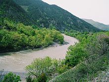
The river is 181 km (112 mi) long. The sources of the Shkumbin river are in the Valamara mountains southwest of Lake Ohrid, near the village Llëngë in the Korçë County. The Shkumbin is fed by the waters of the Dushna, Radicina, Bushtrica, Sheja, Hotolisht, and Dragostunja streams. The Shkumbin flows generally north through Proptisht and Qukës, then northwest to the town of Librazhd, where it turns west and continues through Polis, Elbasan, Cërrik, Peqin and Rrogozhinë. It flows into the Adriatic Sea northwest of Divjakë. The river Rapun joins the Shkumbin near Librazhd.
The two canals "Naum Panxhi" and "Ferras" stem out of the river in the Elbasan area and through an irrigation plan system satisfy the agricultural water needs of the Cërrik low plains.