
OS grid reference SK394583 Post town ALFRETON | Sovereign state United Kingdom Local time Saturday 9:41 PM | |
 | ||
Weather 8°C, Wind W at 13 km/h, 84% Humidity | ||
Shirland is a village in the North East Derbyshire district of Derbyshire, England. Together with the neighbouring villages of Higham, Stretton and Stonebroom, it forms part of the civil parish of Shirland and Higham. The population of this civil parish at the 2011 Census was 4,802. Formerly a mining village, Shirland has existed since at least 1086. Local politics is largely Labour. The River Amber flows through the parish.
Contents
Map of Shirland, Alfreton, UK
History
Shirland is mentioned in the Domesday Book as Sirelunt in the hundred of Scarsdale. According to this ancient document the manor was given to William de Peveral after the Norman conquest. Peveral inherited many manors around Derbyshire and Nottinghamshire including Nottingham Castle.
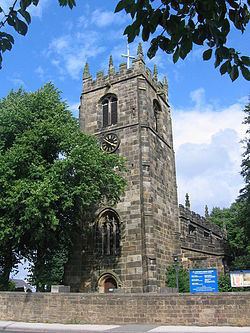
The village is built around St. Leonard's Church. The foundations of the church date to 1220, according to the inscriptions within the church. The church grounds contain many monuments to the De Grey family, who inherited the manor in the early 13th century. The church also contains memorials to the Revill family who were well-known Derbyshire landowners in the 15th century.
Gables Farm (now demolished) at Higham in Shirland Parish was built in 1696 by Thomas and Anne Clay on a 64-acre plot.
In 1868 the inhabitants were mostly involved with agriculture but a proportion were involved with framework knitting. However, in 1864 a mine was founded, which by the end of the century employed 500 men. The community together with Higham increased from a population of 2,437 in 1871 to 3,415 in 1881. The mines shaped the community until 1965 when the mine closed. A golf course is now built on the former slag heaps.
A new primary school was opened in September 2011, next to St. Leonards Church.
Church
The buttressed west tower of St Leonard's Church, Shirland is pictured above, alongside the A61 north of Alfreton. Parts of the church date from 1220 but the majority of the existing church is 15th-century. It is part of a Benefice with the Church of England churches in Stonebroom (St Peter's Church) and Morton: (Church of the Holy Cross).