
OS grid reference SK391590 Post town ALFRETON Local time Saturday 10:32 AM | Sovereign state United Kingdom Postcode district DE55 Dialling code 01773 | |
 | ||
Weather 11°C, Wind S at 16 km/h, 88% Humidity | ||
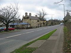
Higham is a small village in Derbyshire, England. It is located on the B6013 and A61 roads. Nearby settlements include Shirland, Stretton, Alfreton and Clay Cross. The population is included in the civil parish of Shirland and Higham. Higham is a name of Saxon origin.
Map of Higham, Alfreton, UK
The village is home to the Crown Inn and the Greyhound public houses. The village does not have a church of its own, sharing St Leonards church with neighbouring Shirland.
In 1250–1251, the village was given "borough" status by the Earl of Derby: he freed his villeins, turned their holdings into "burgages" and started an annual fair.
References
Higham, Derbyshire Wikipedia(Text) CC BY-SA