
Population 4,660 (1992) Area 1,149 km² Council seat Yackandandah | Established 1862 Founded 1862 | |
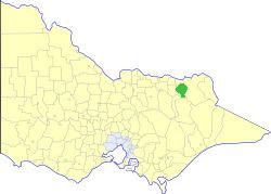 | ||
The Shire of Yackandandah was a local government area about 290 kilometres (180 mi) northeast of Melbourne, the state capital of Victoria, Australia. The shire covered an area of 1,148.75 square kilometres (443.5 sq mi), and existed from 1862 until 1994.
Contents
History
Yackandandah was incorporated as a road district on 8 August 1862, and became a shire on 30 December 1864. It was originally created with a larger area, but it lost land to the Shire of Chiltern in two transfers; on 14 May 1913 and 30 May 1917.
On 18 November 1994, the Shire of Yackandandah was abolished, and, along with most of the Shires of Beechworth, Chiltern and Rutherglen, was merged into the newly created Shire of Indigo. The Baranduda district was transferred to the Rural City of Wodonga, while the Dederang district was transferred into the newly created Alpine Shire.
Wards
The Shire of Yackandandah was divided into three ridings:
Towns and localities
Population
* Estimate in the 1958 Victorian Year Book.