
Population 3,560 (1992) Area 530.9 km² | Established 1862 Founded 1862 | |
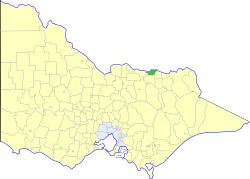 | ||
The Shire of Rutherglen was a local government area about 275 kilometres (171 mi) north-northeast of Melbourne, the state capital of Victoria, Australia. The shire covered an area of 530.9 square kilometres (205.0 sq mi), and existed from 1862 until 1994.
Contents
History
Rutherglen was incorporated as a road district on 12 September 1862 and became a shire on 16 June 1871. Part of its Lilliput Riding was lost to the Shire of Chiltern in February 1917. On 15 December 1920, the Borough of Rutherglen, which had been gazetted on 12 September 1862 with an area of 518 hectares (1,280 acres), was merged into the Shire as its Central Riding.
On 18 November 1994, the Shire was abolished, and merged with most of the Shires of Beechworth, Chiltern and Yackandandah into the Shire of Indigo.
Wards
Rutherglen was divided into three wards, each of which elected three councillors:
Towns and localities
Population
* Estimate in the 1958 Victorian Year Book.